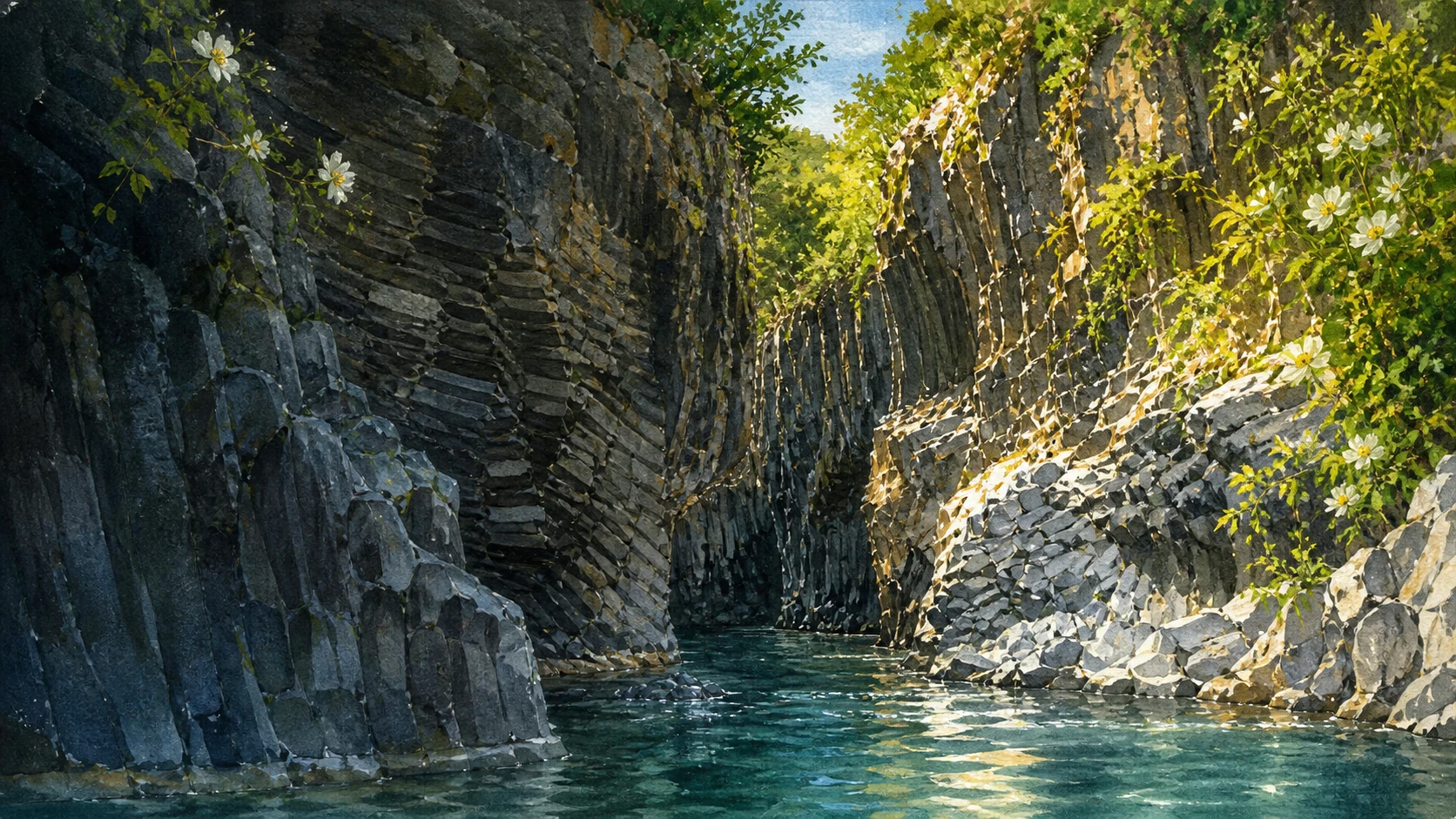
Documentary watercolour of the Alcantara river flowing through dark columnar basalt walls with cool blue-green water, ferns, willows, spring flowers and highland light

Illustrated guide · Sicily

A river between
lava and mountains

Ten places through which to read the Alcantara as a complete watershed: Nebrodi springs, Etna lava, Byzantine and medieval towns, riparian life, vineyards and the Ionian mouth.

Explore the places
Alcantara · source, gorges, villages and mouth

A river is larger than its most famous gorge

The Alcantara should not be entered through a ticket gate and left there.

Its water begins beneath Floresta in the eastern Nebrodi, gathers near Randazzo and follows the boundary between mountain systems. On one bank rise the Peloritani and Nebrodi; on the other, the northern slopes of Etna have repeatedly sent lava toward the old riverbed.

The spectacular basalt canyon at Larderia is one result of that encounter, not the whole explanation. Springs, gurne, willows, orchards, bridges, Byzantine architecture, medieval fortifications and river towns belong to the same basin.

A complete journey follows the water from source to sea and allows each community to keep its own history. The valley is a corridor between Sicily's mountains, not a decorative annex to Taormina or Etna.

One destination

Alcantara,
fifty kilometres of changing ground.

The Alcantara basin covers roughly 573 square kilometres and the river travels about fifty kilometres to the Ionian Sea. The park authority divides its course into changing geological and ecological sectors: steep sedimentary highlands near the source, the upper valley around Randazzo, basalt and spring-fed middle reaches, and a lower alluvial plain near the mouth.

Etna lava entered and altered earlier channels. Slow cooling created jointed basalt, while persistent water exposed, cut and rearranged those masses into columns, cascades, pools and narrow gorges. Yet the river is also sustained by Etna's groundwater, making it one of Sicily's important perennial rivers and the only one protected through a dedicated regional river park.

The selection

Ten places,
one watershed from source to sea

The route begins below Floresta, follows the upper valley through Randazzo and Mojo, crosses Castiglione and its Byzantine countryside, enters the Francavilla and Motta Camastra gorge system, and finishes with riparian habitat, farms and the Ionian mouth.

  1. 01The Source Below Floresta and the Upper Alcantara
  2. 02Randazzo and the Upper-Valley Crossing
  3. 03Monte Mojo and the Valley's Small Volcano
  4. 04Castiglione di Sicilia and the Castello di Lauria
  5. 05The Cuba of Santa Domenica
  6. 06Francavilla di Sicilia and the Gurne
  7. 07Motta Camastra and the Gorge Villages
  8. 08The Gole dell'Alcantara at Larderia
  9. 09The Piccole Gole and Riparian Corridor
  10. 10Etna Vineyards, the Lower Plain and the Ionian Mouth
01

A mountain river begins among sedimentary rocks, rain and springs

The Source Below Floresta and the Upper Alcantara

The river's first sector belongs to the Nebrodi highlands before Etna lava becomes the dominant visual story.

Documentary watercolour of the Cuba of Santa Domenica with its dark stone dome and apses among lava walls and olive trees in the Alcantara Valley
A SMALL DOMED CHURCH IN A VOLCANIC LANDSCAPE

The place today

The park authority places the source sector around Monte Calarvelo and the Gacci spring, below Floresta at roughly 1,378 metres. Small channels gather through Piano Grande and meet other springs before a clearer main bed develops near Randazzo. Forest plantations, pasture, wet ground and steep tributaries give this upper course a different character from the tourist gorge far downstream.

The historical chapter

Rain and snowmelt on the eastern Nebrodi feed surface flow, while the basin's later sections receive significant groundwater from Etna. Mid-twentieth-century reforestation introduced or reinforced chestnut, alder, black pine and beech in parts of the upper catchment. Reading the source requires caution: a river originates through a network of water and terrain rather than one permanent fountain, and seasonal conditions can change what is visible.

What to notice

  • Sedimentary mountain slopes before basalt appears in the channel
  • Small tributaries and wet soils joining into a recognisable river course
  • Plantation woodland distinguished from older riparian and pasture habitats
Alcantara River Park · Riparian vegetation and source
02

A medieval stone town stands where Etna, Nebrodi and river routes meet

Randazzo and the Upper-Valley Crossing

Lava architecture, royal history and a strategic crossing give the upper Alcantara an urban centre of its own.

Documentary watercolour of the Cuba of Santa Domenica with its dark stone dome and apses among lava walls and olive trees in the Alcantara Valley
A SMALL DOMED CHURCH IN A VOLCANIC LANDSCAPE

The place today

Randazzo stands above the river on Etna's north-western side, built largely in dark lava stone. The Basilica of Santa Maria combines black volcanic masonry with pale sandstone details, medieval portals, a later bell tower and works accumulated across centuries. Gates, towers, narrow streets and former religious quarters preserve the scale of a town shaped by movement between Messina, Catania and the interior.

The historical chapter

Different linguistic and religious communities contributed to medieval Randazzo, which became important under Norman, Swabian and Aragonese rulers. Royal campaigns restored walls and gates and supported churches and noble residences. Santa Maria's present form ranges from the thirteenth century to nineteenth-century work, so it cannot be assigned to one style. The river below helped connect rather than isolate the town, carrying routes along the mountain frontier.

What to notice

  • Black lava blocks and pale carved stone used as an architectural dialogue
  • Fortified gates oriented toward older regional routes
  • The river valley and railway corridors visible as part of Randazzo's strategic setting
Municipality of Randazzo · Basilica and town history
03

A low cone proves that Etna's northern volcanic field reaches the river

Monte Mojo and the Valley's Small Volcano

Black-red pyroclastic layers at Mojo Alcantara offer a compact lesson in the volcanic processes behind the valley.

Documentary watercolour of the Cuba of Santa Domenica with its dark stone dome and apses among lava walls and olive trees in the Alcantara Valley
A SMALL DOMED CHURCH IN A VOLCANIC LANDSCAPE

The place today

Monte Mojo rises as a distinct low cone close to the river and the village of Mojo Alcantara. Its slopes show dark and reddish pyroclastic material rather than the massive jointed lava of the gorges. Fields and paths surround the cone, making its form easier to understand from a distance than from one summit view. Conditions and authorised routes should be checked locally.

The historical chapter

The park identifies Monte Mojo as one of the valley's principal vulcanological sites. It belongs to the broader northern Etna volcanic system, but its eruption history and relationship to individual river lavas require specialist interpretation. The responsible point is morphological: loose explosive deposits built a cone, while other lava bodies entered channels and cooled into the basalt later exposed by water. Not every dark rock in the valley came from the same event.

What to notice

  • Layered black and red pyroclastic deposits distinct from columnar basalt
  • The cone's low, regular profile against higher Nebrodi and Etna slopes
  • Agricultural boundaries crossing volcanic ground rather than avoiding it
Alcantara River Park · Geology and Monte Mojo
04

A fortified town controls the middle valley from a basalt and sandstone ridge

Castiglione di Sicilia and the Castello di Lauria

Castle, towers, churches and a former Jewish quarter reveal a strategic community between river and Etna vineyards.

Documentary watercolour of the Cuba of Santa Domenica with its dark stone dome and apses among lava walls and olive trees in the Alcantara Valley
A SMALL DOMED CHURCH IN A VOLCANIC LANDSCAPE

The place today

Castiglione rises above the Alcantara with the Castello di Lauria occupying its highest fortified position. Surviving halls, cisterns, prison spaces, walls and rock-cut elements belong to several phases rather than one intact Norman castle. Below, lanes pass churches, the isolated tower known as U Cannizzu and traces of the Giudecca. Views connect the river corridor with terraces on Etna's northern flank.

The historical chapter

Written forms of the place-name in the twelfth century emphasise the castle, while the principal fortified nucleus is generally associated with Norman-Swabian phases and later feudal use. The town also preserves memory of a Jewish community present before the 1492 expulsion from the Spanish kingdoms. Repeated rebuilding and changed functions transformed the castle. Its current regional-wine use adds a modern layer but should not replace the military and social history of the site.

What to notice

  • Cisterns and service spaces showing that a fortress was also a residential system
  • The separate U Cannizzu tower within the broader defensive landscape
  • Terraced vineyards occupying the same views once monitored for movement and attack
Municipality of Castiglione di Sicilia · Castello di Lauria
Documentary watercolour of the Cuba of Santa Domenica with its dark stone dome and apses among lava walls and olive trees in the Alcantara Valley
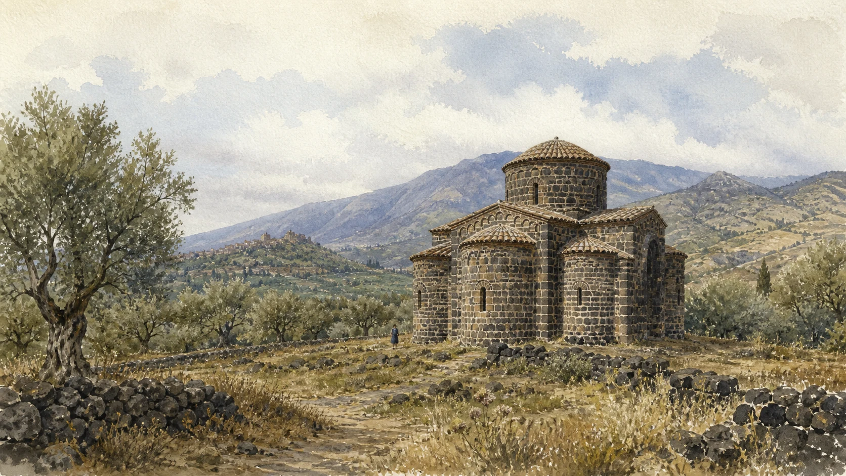
A SMALL DOMED CHURCH IN A VOLCANIC LANDSCAPEThe Cuba of Santa Domenica joins Byzantine building form, rough dark masonry, olive ground and the strategic crossings of the middle valley.
05

A small domed church preserves the valley's Byzantine architectural horizon

The Cuba of Santa Domenica

Outside Castiglione, a compact rural building complicates the assumption that the valley's history begins with Norman castles.

Documentary watercolour of the Cuba of Santa Domenica with its dark stone dome and apses among lava walls and olive trees in the Alcantara Valley
A SMALL DOMED CHURCH IN A VOLCANIC LANDSCAPE

The place today

Santa Domenica stands in open countryside as a small, strongly modelled stone church traditionally described as a Byzantine cuba. Its centralised mass, domed volumes and three-part eastern termination are read against fields and Etna's northern landscape. The building should be approached as protected rural architecture: access, keys and interior opening cannot be assumed from its visibility beside a road.

The historical chapter

The Municipality places the church broadly between the seventh and ninth centuries, while detailed dating and interpretation have been debated. Its form belongs to the eastern Christian architectural traditions that continued in Sicily before and around later political transformations. The church may once have carried richer painted decoration. Its survival demonstrates cultural continuity and exchange in the valley before the more visible Norman-Swabian monuments.

What to notice

  • The compact central volume and apsidal forms rather than a later longitudinal basilica plan
  • Stone construction integrated with agricultural ground and dry walls
  • Missing or altered decoration reminding the visitor that survival is partial
Municipality of Castiglione di Sicilia · Historic town and Santa Domenica
06

Pools, small falls and a river town reveal the valley at human scale

Francavilla di Sicilia and the Gurne

The Alcantara broadens and steps through lava near the park's administrative centre before entering its narrowest canyon.

Documentary watercolour of the Cuba of Santa Domenica with its dark stone dome and apses among lava walls and olive trees in the Alcantara Valley
A SMALL DOMED CHURCH IN A VOLCANIC LANDSCAPE

The place today

Around Francavilla, the river forms gurne—pools and depressions—linked by short cascades across uneven lava and sediment. Paths and viewpoints vary in maintenance and difficulty. The town stands between the Alcantara and Zavianni valleys and hosts the river park's administrative centre. Its Capuchin convent preserves a museum of Franciscan testimony and a herbarium connected to local medicinal plants.

The historical chapter

Francavilla developed as a strategic settlement in a fertile meeting of valleys, passing through medieval lordships and later agricultural expansion. The gurne result from river erosion exploiting fractures and level changes in the bed; they are not designed swimming pools. Mills, irrigation and crossings once used the same water in practical ways. The modern park placed its offices here to connect ecological protection with communities living along the river.

What to notice

  • Pools connected by moving water rather than isolated basins
  • Changes from basalt to sediment within short river stretches
  • Convent collections linking botanical knowledge, devotion and valley resources
Alcantara River Park · Journey along the river
07

A compact rock village watches the river from above

Motta Camastra and the Gorge Villages

Motta's steep streets and viewpoints show how settlement avoided the floodplain while remaining tied to the crossing below.

Documentary watercolour of the Cuba of Santa Domenica with its dark stone dome and apses among lava walls and olive trees in the Alcantara Valley
A SMALL DOMED CHURCH IN A VOLCANIC LANDSCAPE

The place today

Motta Camastra clings to a limestone spur above the middle Alcantara. Houses, stairs, short lanes and small piazzas follow the rock rather than a regular plan. From upper viewpoints, the gorge corridor, Etna's northern slope and the approach roads become legible. The principal tourist access to the famous Gole lies in the municipality below, but the village itself is a separate lived centre.

The historical chapter

The fortified settlement grew from medieval control of the valley and later feudal organisation. Its high position protected inhabitants from river flooding and monitored movement through a narrow corridor, while agriculture and crossings kept it economically connected to the floor below. Modern tourism often uses Motta only as an address for the gorge; a fuller reading recognises the social cost and continuity of maintaining a steep small town.

What to notice

  • Building walls and bedrock merging along narrow lanes
  • The distance in height between the village and the river attraction carrying its name
  • Etna, river and Peloritani-Nebrodi slopes visible in one connected panorama
Alcantara River Park · Park municipalities and river journey
08

Columnar basalt records cooling while the river continues its work

The Gole dell'Alcantara at Larderia

The most famous gorge is a four-hundred-metre geological section, not an amusement channel or a frozen lava sculpture.

Documentary watercolour of the Cuba of Santa Domenica with its dark stone dome and apses among lava walls and olive trees in the Alcantara Valley
A SMALL DOMED CHURCH IN A VOLCANIC LANDSCAPE

The place today

At Larderia, the river enters a narrow gorge roughly four hundred metres long, only a few metres wide in places, with walls reaching about fifty metres. Dark basalt joints appear as organ pipes, fans and stacked forms depending on cooling direction and later breakage. Water can be very cold and its level, speed and accessible floor change with season and weather; official viewpoints and authorised activities must be distinguished.

The historical chapter

Etna lava invaded or obstructed an earlier course and cooled slowly enough to develop systematic contraction joints. The river then exposed and incised the lava body, removing weaker material and revealing columns of different orientations. This is not a single instant in which hot lava met today's river and became hexagons. The gorge records multiple processes across long periods: eruption, emplacement, cooling, fracturing, groundwater and erosion.

What to notice

  • Columns changing direction from vertical pipes to fan and woodpile patterns
  • Broken edges and fallen blocks showing that the gorge remains an active erosional system
  • Water line and access structures separated from the geological wall itself
Alcantara River Park · Gole dell'Alcantara
09

Smaller lava reaches make ecology and river continuity easier to observe

The Piccole Gole and Riparian Corridor

Pools, cascades, willows and accessible riverbank sections reveal processes hidden by the drama of the main gorge.

Documentary watercolour of the Cuba of Santa Domenica with its dark stone dome and apses among lava walls and olive trees in the Alcantara Valley
A SMALL DOMED CHURCH IN A VOLCANIC LANDSCAPE

The place today

Near Ponte San Nicola, a park itinerary follows a flatter basalt reach through small gorges, gurne and cascades between Motta Camastra and Castiglione. Riparian trees and shrubs occupy banks where space allows. The endemic Gussone willow is among the species whose survival depends on intact river habitat, alongside white willow, poplar and other plants changing with altitude and substrate.

The historical chapter

The river park was established in 2001 because the Alcantara is an ecological system as well as a geological spectacle. Its vegetation corridor stabilises banks, shades water, supports fauna and connects mountain to coast. Channel works, extraction, pollution, invasive species and unmanaged visitation can interrupt that continuity. Protecting the famous gorge without the lesser reaches would preserve a monument but lose the river that created and sustains it.

What to notice

  • Plant communities changing between exposed basalt, gravel bars and deeper soil
  • Cascades and pools associated with bedrock steps rather than artificial basins
  • Signs and barriers marking conservation needs along apparently gentle terrain
Alcantara River Park · Piccole Gole itinerary
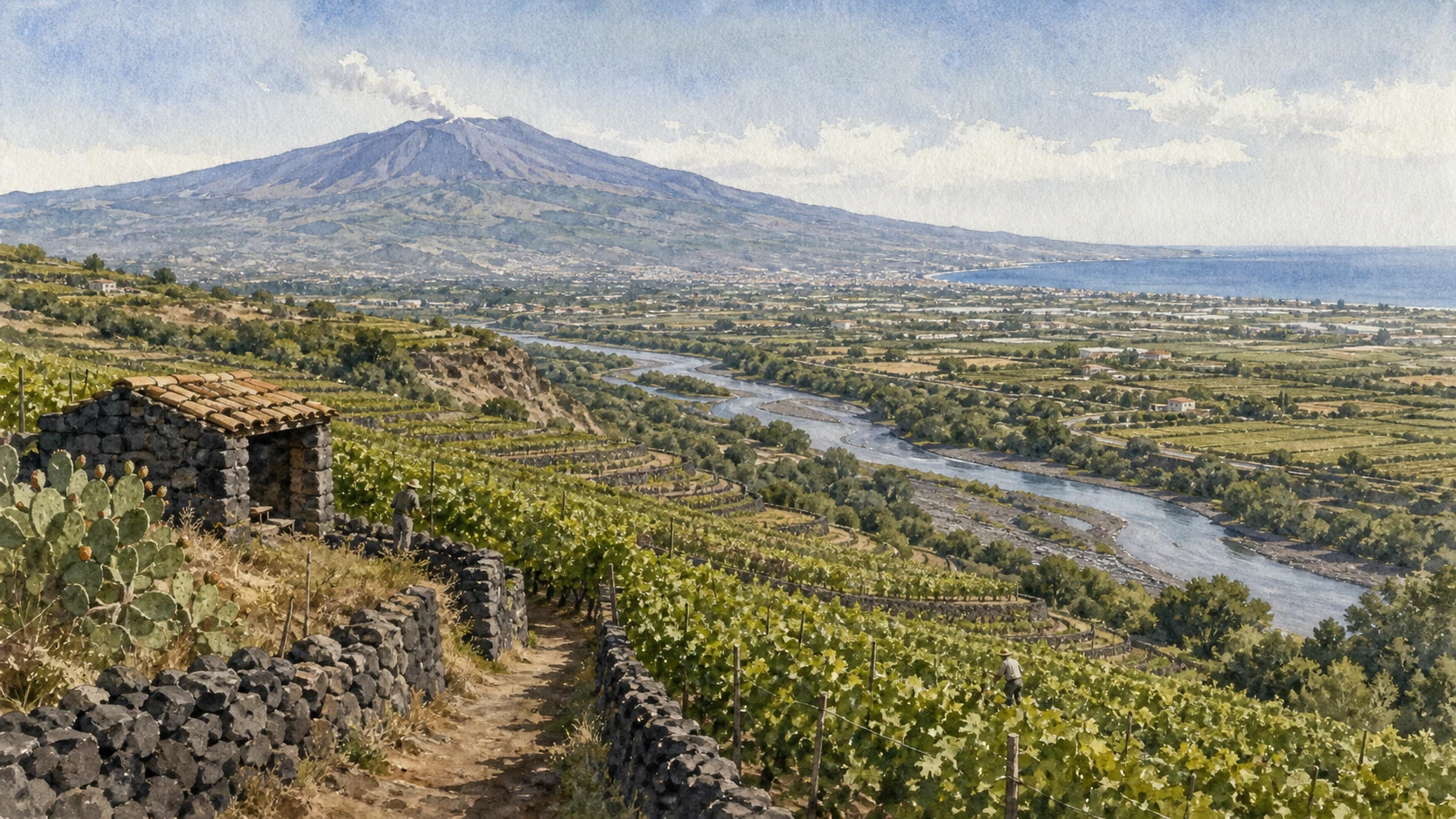
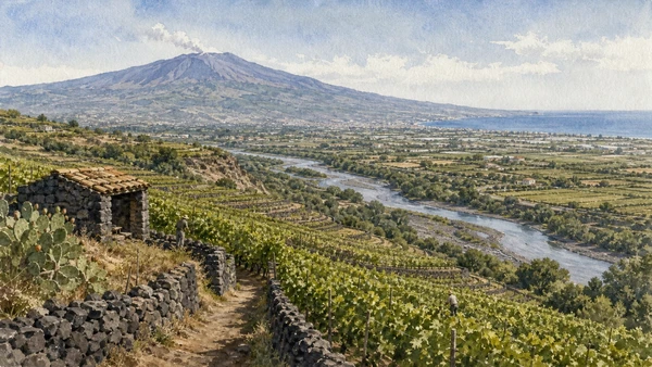
Documentary watercolour of terraced Alcantara vineyards with black lava walls, the river plain, Mount Etna and the distant Ionian coast
VINEYARDS, RIVER PLAIN AND IONIAN HORIZONTerraces held by lava walls descend toward the river corridor, linking Etna farming to the broad lower valley and the sea.
10

The river ends through farms and wet ground, not at the gorge exit

Etna Vineyards, the Lower Plain and the Ionian Mouth

Terraces on volcanic slopes, orchards on alluvium and the river mouth complete the economic and ecological basin.

Documentary watercolour of terraced Alcantara vineyards with black lava walls, the river plain, Mount Etna and the distant Ionian coast
VINEYARDS, RIVER PLAIN AND IONIAN HORIZON

The place today

Below the gorges, the valley opens toward Calatabiano, Giardini Naxos and the Ionian Sea. Citrus, vegetables and orchards use deeper alluvial soils, while vines climb the volcanic terraces toward Castiglione, Linguaglossa and Randazzo. At the mouth, freshwater, gravel, reed and coastal conditions meet. Roads, rail, irrigation and settlement make this the most visibly transformed sector of the river.

The historical chapter

Communities repeatedly adapted the basin's contrasts: volcanic soils and elevation for vines, alluvial flats for intensive cultivation, river water for irrigation and the coastal corridor for trade. Today's Etna wine landscape is a living agricultural system of terraces, dry walls, old vines and new investment, not an untouched continuation of antiquity. The mouth remains ecologically valuable precisely because it sits within infrastructure and farming pressure.

What to notice

  • Volcanic terraces on the southern side contrasted with broader alluvial fields below
  • Irrigation channels and embankments revealing managed water
  • Freshwater vegetation changing as the river approaches salt, wind and coastal sediment
Alcantara River Park · Nature and lower valley

The city through time

Ten thresholds
in a river shaped by fire

The chronology joins geological processes, ancient and medieval crossings, rural development and modern protection without pretending that every lava body or town belongs to one moment.

  1. Etna lava repeatedly enters or alters older drainage on the northern flank; cooling and fracturing create basalt bodies later exposed by the river.

  2. The river known through ancient names including Akesines and Asines forms a route and boundary connected to Naxos and inland settlements.

  3. The Cuba of Santa Domenica represents eastern Christian architecture in the Castiglione countryside before Norman rule.

  4. Place-names, bridges, castles and agricultural organisation change across the valley; forms of al-Qantarah contribute to the river's later name.

  5. Randazzo, Castiglione and other fortified centres gain strategic importance under Norman, Swabian and Aragonese rulers.

  6. The expulsion of Jews from the Spanish kingdoms ends the documented Jewish presence remembered in Castiglione's Giudecca and other Sicilian towns.

  7. Churches, estates, mills, irrigation and expanding agriculture reshape the inhabited basin while river processes continue independently.

  8. Rail, roads, emigration, tourism and new agricultural markets reconnect and depopulate different parts of the valley in unequal ways.

  9. Regional law establishes the Alcantara River Park, replacing earlier reserve protection with a basin-scale public institution.

  10. Conservation must balance river ecology, geological access, flood and slope safety, agriculture, resident communities and intense seasonal visitation.

Before your visit

Practical information,
without turning it into promises

01

Separate viewpoints from river entry

Seeing the gorge from above and entering the cold channel are different activities with different safety requirements. Check water, weather, authorised operators and the exact access point before descending.

02

Travel the valley in sections

Source, Randazzo, Castiglione, Francavilla, Motta, gorges and mouth are not one compact stop. Divide the basin into upper, middle and lower days rather than chasing ten pins.

03

Verify small-site openings

Castles, the Cuba, convent collections and local museums often depend on municipal or seasonal arrangements. A visible monument is not automatically open, staffed or safe inside.

04

Protect water and farms

Remain on marked paths, avoid entering cultivated terraces and never treat pools as consequence-free swimming places. The valley is a working watershed and private agricultural landscape.

Sources

This guide treats the Alcantara as a watershed and cross-checks the official river park's geological, botanical, territorial and itinerary material against municipal sources for Castiglione and Randazzo and the Etna park's northern municipalities. It distinguishes verified formations from simplified lava-water legends, and public viewpoints from activities requiring current safety information.

The hero image is an illustration, not a photograph. Water level, current, temperature, trail condition, gorge access, municipal openings and private-land boundaries can change; consult the linked park and municipal sources shortly before visiting. Never enter a river channel during adverse weather or without the required authorised support.