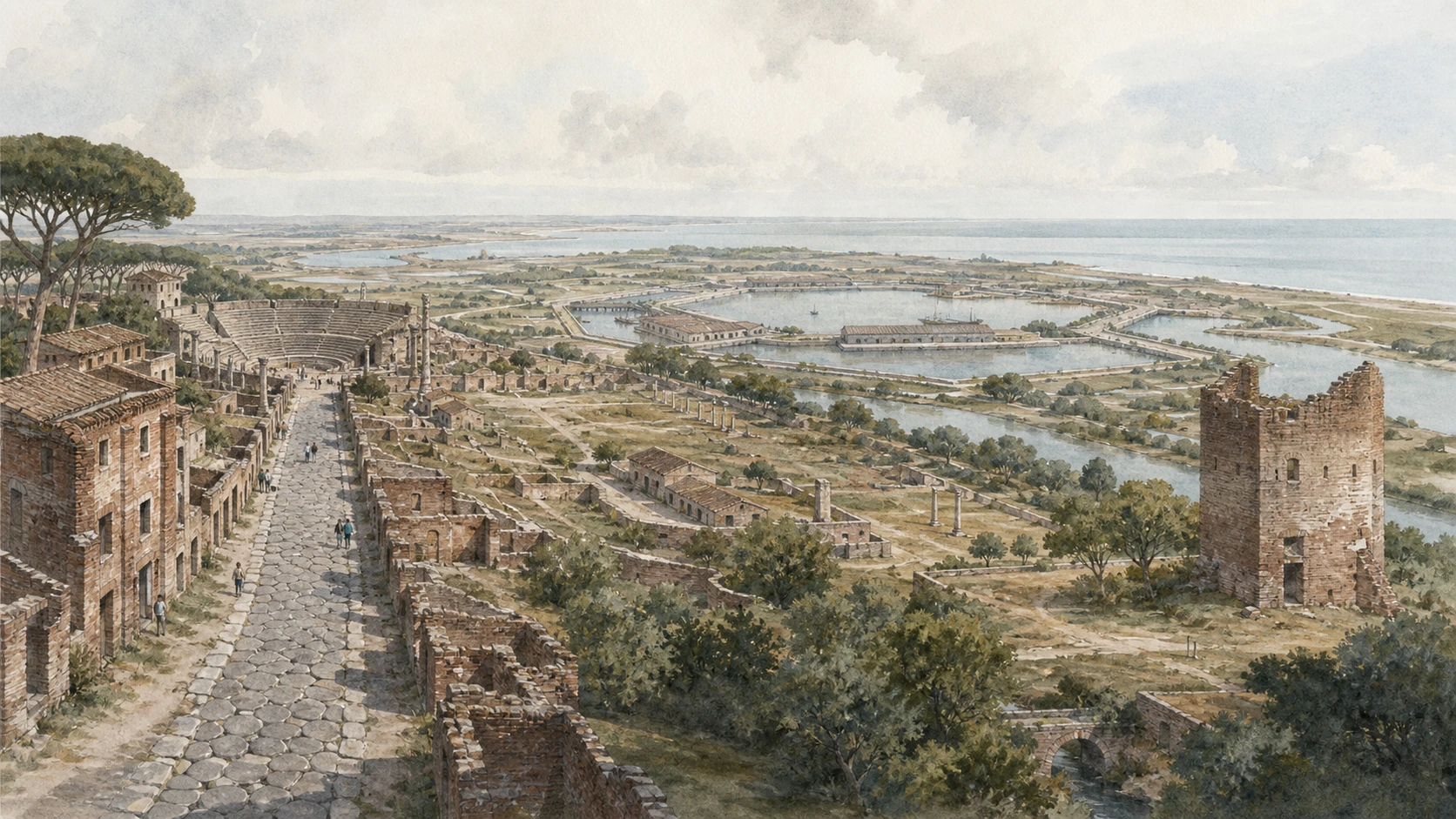
Original documentary watercolour joining Ostia's Decumanus, theatre, Trajanic harbour and the changed Tiber delta

Rome Guide 17 · Port city, supply system and moving delta

Ostia Antica
and the
Tiber Mouth

A full-day archaeological route from Ostia's gate, baths, theatre, forum and working streets to its medieval successor, the imperial harbours, Isola Sacra and a river mouth transformed by sediment and flood.

Plan the route
Ostia · Portus · Isola Sacra10 chapters · city plus delta

Why this district matters

Ostia is not a seaside Pompeii: it is Rome's long-lived port city, repeatedly rebuilt as river, coast and imperial logistics changed.

Ancient literature attributed Ostia's foundation to King Ancus Marcius and the salt pans at the Tiber mouth, but the earliest secure settlement is the fourth-century BC fortified colony. From that castrum the city expanded along the Cardo and Decumanus. Warehouses, baths, guild buildings, apartment blocks, temples and workshops multiplied as Ostia handled people and goods moving between the Mediterranean, the river and Rome. The ruins visible today are therefore dominated by imperial rebuilding, especially under Hadrian and the Antonines, rather than one frozen founding moment.

The city worked within a wider port system. Claudius began an enormous maritime basin north of the river mouth in AD 42; Trajan added the famous hexagonal harbour around AD 110. Ocean-going cargoes could be transferred to river craft and hauled upstream. Ostia continued to house commercial, administrative and residential life even after Portus acquired the largest ships and warehouses. The Square of the Guilds, granaries, mills and Fiumicino ship hulls document connected stages of exchange, not rival ports that replaced one another overnight.

The landscape is an archaeological fact. The Tyrrhenian shore now lies kilometres from ancient Portus, the Tiber no longer runs beside Ostia's northern edge, and the flood of 1557 helped shift the active channel away from the Renaissance castle. Tor Boacciana, Isola Sacra and the Fossa Traiana make the changing delta visible. A complete visit cannot be compressed into one gate-to-gate stroll: Ostia, Portus, the ship museum, the Portus necropolis and the castle keep separate hours, entrances and access conditions. Use the combined ticket across days if the current rules still support it.

Read the excavated city first, then use Portus and Isola Sacra to restore the sea, river, ships, tomb roads and distances that modern roads and the airport have broken apart.

The route

Plan your visit

Begin at Porta Romana and follow the Decumanus through the baths, theatre and commercial square to the Forum. Detour into Via di Diana and the grain-working district before reaching the synagogue and later city. The castle and hamlet form a post-antique coda. Portus, the ship museum and Isola Sacra require separate transfers and may be better used as a second day rather than a hurried appendix.

Morning I

Gate, water and theatre

Establish the ancient river and coast before reading the Baths of Neptune, fire brigade, theatre and trading stationes.

Morning II

Forum and working streets

Compare official monuments with apartment blocks, bars, granaries and mills; Ostia's urban life is the argument, not background scenery.

Afternoon I

Communities and afterlife

Use the synagogue, late buildings, museum and medieval hamlet to resist the myth that the port simply vanished in one late-antique collapse.

Afternoon II or day two

Portus and the delta

Transfer to the imperial harbours, ship museum and Isola Sacra only after checking separate openings, restoration notices and transport time.

Ten chapters

Explore the places

The route restores the missing river, coast and harbour system while moving from civic monument to work, housing, worship and the later delta. Use the index without detaching a site from water and logistics.

  1. 01Porta Romana, the necropolis and Decumanus
  2. 02The Baths of Neptune and Barracks of the Vigiles
  3. 03The Theatre and Square of the Guilds
  4. 04The Forum, Capitolium and imperial cult
  5. 05Casa di Diana and the Thermopolium
  6. 06The grain system: horrea, mills and bakeries
  7. 07The Synagogue and Ostia's religious plurality
  8. 08The Hamlet and Castle of Julius II
  9. 09Portus and the Roman Ships Museum
  10. 10Isola Sacra, the Portus necropolis and Tor Boacciana
01

A fourth-century BC colony grew beyond its walls until the gate became the beginning of an imperial urban avenue

Porta Romana, the necropolis and Decumanus

The approach distinguishes literary foundation, archaeological settlement, suburban tomb road and the later monumentality of the main street.

Today

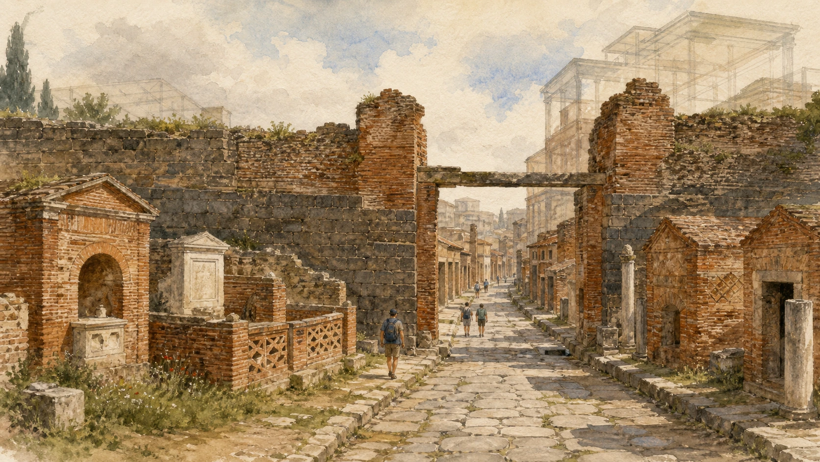
The visitor crosses the Via Ostiensis necropolis before entering through the remains of Porta Romana. Inside, the Decumanus runs west across the excavated city, its basalt paving bordered by tombs, shops, porticoes, baths and public monuments. The road appears dramatically straight, but preserved surfaces, ancient drains and restored walls belong to different phases. The modern entrance route also edits what can be seen: Ostia extended far beyond the most familiar corridor, while the ancient Tiber ran close to the city's northern side.

History

Roman tradition credited King Ancus Marcius with founding Ostia around 620 BC to control salt at the river mouth. Archaeology instead securely identifies a fortified castrum of the fourth century BC. A larger wall circuit and monumental gates were built in the first century BC as settlement expanded. Porta Romana received inscriptions and decoration under imperial patronage, while burials lined the road outside because Roman law and custom generally kept tombs beyond the inhabited boundary.

How to read this place

The traditional royal foundation date and the excavated city belong to different kinds of evidence; much of the standing brick fabric is later than the fourth century BC. The castrum survives principally in alignments and buried walls inside a much later city. Outside the gate, funerary monuments were not a separate cemetery park but part of the travelled approach. Reconstruct the missing river and shoreline before treating the Decumanus as an inland boulevard: the word Ostia itself derives from ostium, a mouth or entrance.

What to notice

  • Tomb façades addressing travellers before the gate
  • Basalt carriage surface, drains and raised pedestrian edges
  • Changes of masonry revealing repeated reconstruction along one axis
Archaeological Park of Ostia Antica · general history and urban development
Original documentary watercolour of Porta Romana, roadside tombs and the Decumanus leading into ancient Ostia
Porta Romana, the necropolis and DecumanusOriginal Merlintravel documentary watercolour · 2026
02

Monumental mosaics and a professional fire brigade expose the infrastructure behind an apartment city

The Baths of Neptune and Barracks of the Vigiles

Water, exercise, spectacle and fire control were public systems, not picturesque extras to the ruins.

Today

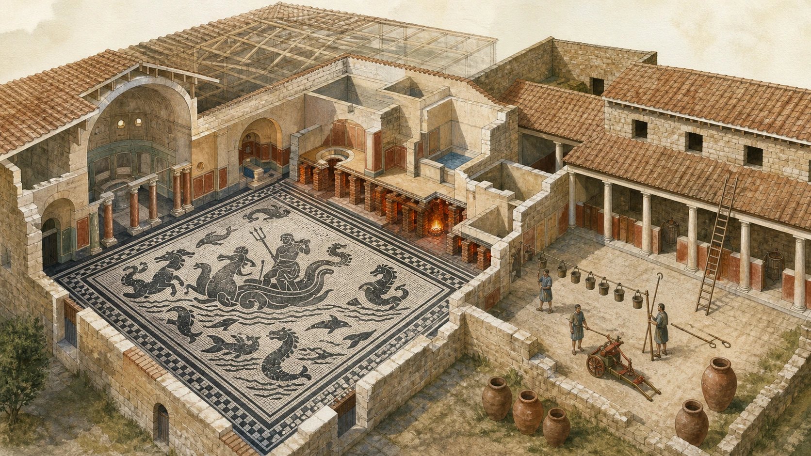
A raised viewpoint reveals the black-and-white marine mosaics of the Baths of Neptune: Neptune's chariot, sea creatures and nereids spread across large rooms beside the palaestra. Nearby, the barracks of the vigiles preserves a courtyard, service rooms and a sanctuary connected with Rome's fire-fighting and night-watch corps. Seasonal protective coverings may hide vulnerable mosaics even when the monument is open. The walls now expose plans clearly, but roofs, water, furnishings, heat and crowds that made the complex work are absent.

History

Earlier baths on Via dei Vigili preceded the grand complex built and decorated principally in the Hadrianic and Antonine periods. Public benefaction and imperial administration transformed bathing into a monumental civic amenity. The vigiles maintained a permanent Ostian detachment because multi-storey housing, warehouses, workshops and lamps created constant fire risk. Their seat developed through several phases and included the Caesareum, where imperial cult bound municipal service to state loyalty.

How to read this place

The mosaics are Roman floors, not pictures intended to be read vertically from the modern overlook. Their sea imagery connected bodily movement and water to the port city's identity. Do not assume every visible basin was a swimming pool or that brick chambers were bare red interiors; marble revetment, plaster and installations have vanished. A covered mosaic is not a failed visit but preventive conservation. Check the Park's seasonal notice instead of promising a specific floor will be exposed.

What to notice

  • Neptune's chariot aligned across a room-scale pavement
  • Palaestra and bathing rooms as a coordinated sequence
  • Barracks courtyard and cult room serving an urban emergency force
Archaeological Park of Ostia Antica · seasonal mosaic conservation
Original documentary watercolour cutaway of the Baths of Neptune mosaics and the adjacent barracks of the vigiles
The Baths of Neptune and Barracks of the VigilesOriginal Merlintravel documentary watercolour · 2026
03

Performance architecture opened directly into a commercial map of Mediterranean shippers and traders

The Theatre and Square of the Guilds

Theatre, portico, temple and mosaic stationes formed one evolving public and corporate district beside the river route.

Today

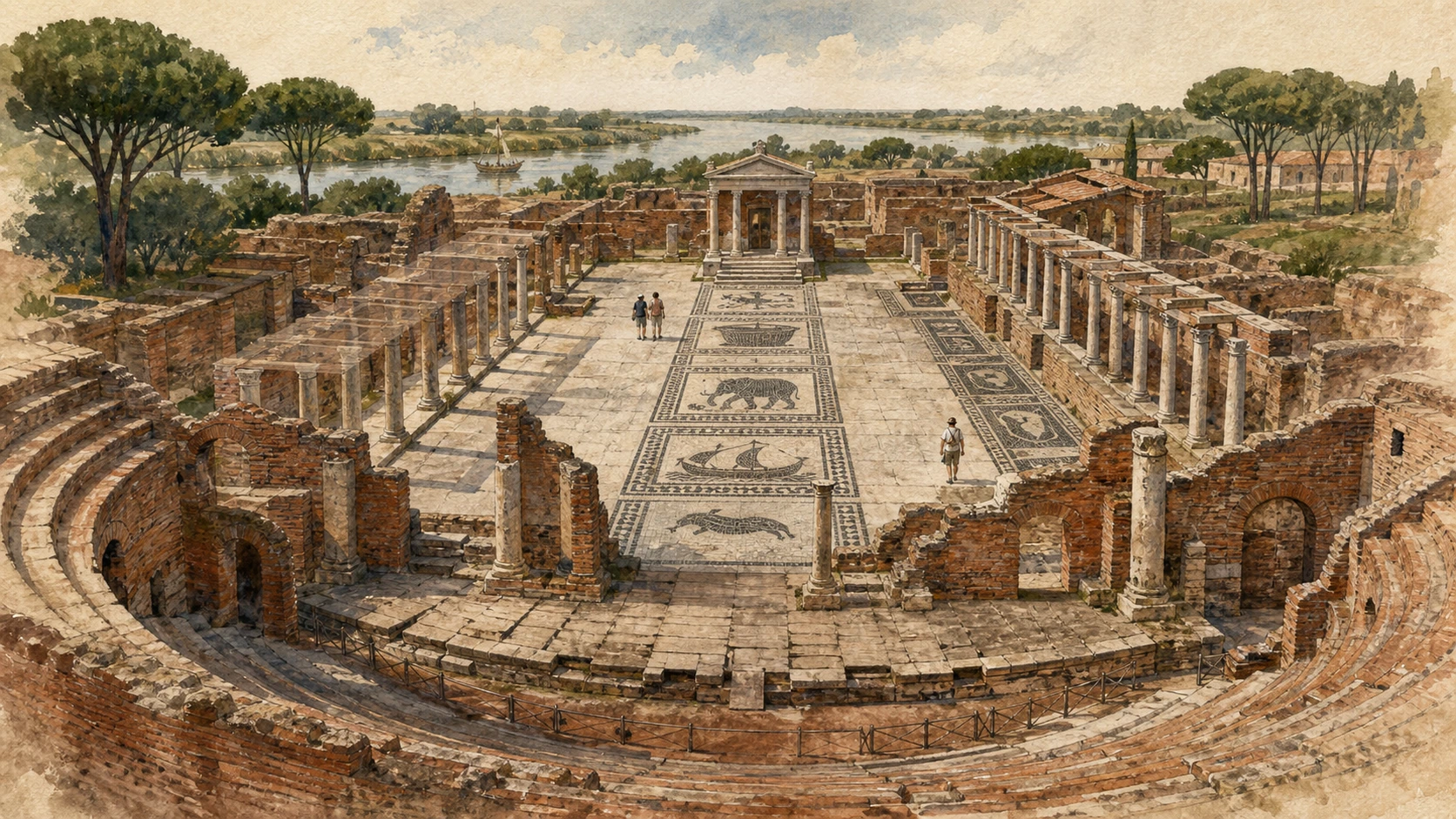
The theatre's semicircular cavea faces a partly reconstructed stage zone, while shops open along the Decumanus frontage. Behind it, the Square of the Guilds forms a large porticoed rectangle around a central temple. Black-and-white mosaics identify shipowners, traders and cities through vessels, grain measures, dolphins, elephants and inscriptions. Modern performances still use the theatre, but current seating and staging must not be mistaken for untouched Roman fabric; excavation and restoration strongly shaped the monument's legibility.

History

Agrippa sponsored the first masonry theatre in the last years of the first century BC. It was enlarged in the late second century AD to accommodate about four thousand spectators, and an arch honouring Caracalla marked an entrance in AD 216. The square was conceived in the Augustan period, porticoed under Claudius and repeatedly subdivided into stationes. Its inscriptions connect Ostia with North African and Mediterranean trading centres, though the exact activity performed in each room remains debated.

How to read this place

The mosaics are evidence for networks and corporate representation, not a complete ancient shipping timetable. A place-name or ship image does not prove that a modern nation maintained an embassy here. The central temple's deity is uncertain, so confident labels should be resisted. Move from the cavea through the square toward the lost river: the architectural relationship makes commerce part of public spectacle and civic status rather than an invisible supply chain.

What to notice

  • Agrippan inscription and later enlargement in the theatre
  • Mosaic stationes naming trading communities and occupations
  • The square's former opening toward the Tiber before later landscape change
Archaeological Park of Ostia Antica · theatre district
Original documentary watercolour joining Ostia's theatre with the mosaic stationes of the Square of the Guilds
The Theatre and Square of the GuildsOriginal Merlintravel documentary watercolour · 2026
04

At the Cardo-Decumanus crossing, temples, basilica, baths and honorary space made civic hierarchy architectural

The Forum, Capitolium and imperial cult

The monumental centre is a layered crossing developed from the republican castrum through Hadrianic rebuilding.

Today

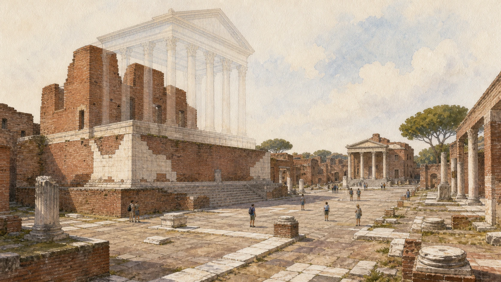
The high brick podium of the Capitolium dominates the north side of the Forum. Opposite stood the Temple of Roma and Augustus; the Basilica occupied the west, while the Forum Baths and public buildings closed other sides. Marble thresholds, fragments and robbed wall faces show how different the ancient square was from the exposed brick landscape. The present openness is useful for reading axes but misleading about shade, porticoes, statues, paving, colour and the pressure of surrounding buildings.

History

The Forum occupied the crossing at the centre of the fourth-century BC castrum. Its recognisable monumental form developed in the early imperial period and was reorganised around AD 120. The Hadrianic Capitolium, dedicated to Jupiter, Juno and Minerva, rose over earlier cult buildings; its six-column porch and marble facing are lost. The opposing Temple of Roma and Augustus articulated loyalty to Rome and imperial power, while the Basilica served judicial and administrative functions rather than Christian worship.

How to read this place

Capitolium names a civic temple, not the hill in Rome, and the Basilica is an official hall, not a church. The surviving brick core was once revetted in marble, so 'brick architecture' describes the exposed structure rather than the finished appearance. Stand off-axis to see how the earlier castrum grid remained inside later monumentality. Honorary bases without statues record removal and reuse as much as ancient commemoration.

What to notice

  • Cardo and Decumanus crossing beneath the monumental square
  • Capitolium podium, marble threshold and lost six-column porch
  • Opposing civic, judicial and imperial-cult buildings framing one forum
Archaeological Park of Ostia Antica · central area and official complexes
Original documentary watercolour reconstruction study of Ostia's Forum, Capitolium and Temple of Roma and Augustus
The Forum, Capitolium and imperial cultOriginal Merlintravel documentary watercolour · 2026
05

Multi-storey apartments, street shops and a third-century inn make density more visible than elite domestic fantasy

Casa di Diana and the Thermopolium

The surviving lower floors reveal mixed housing, commerce, water display and later religious adaptation within one urban block.

Today

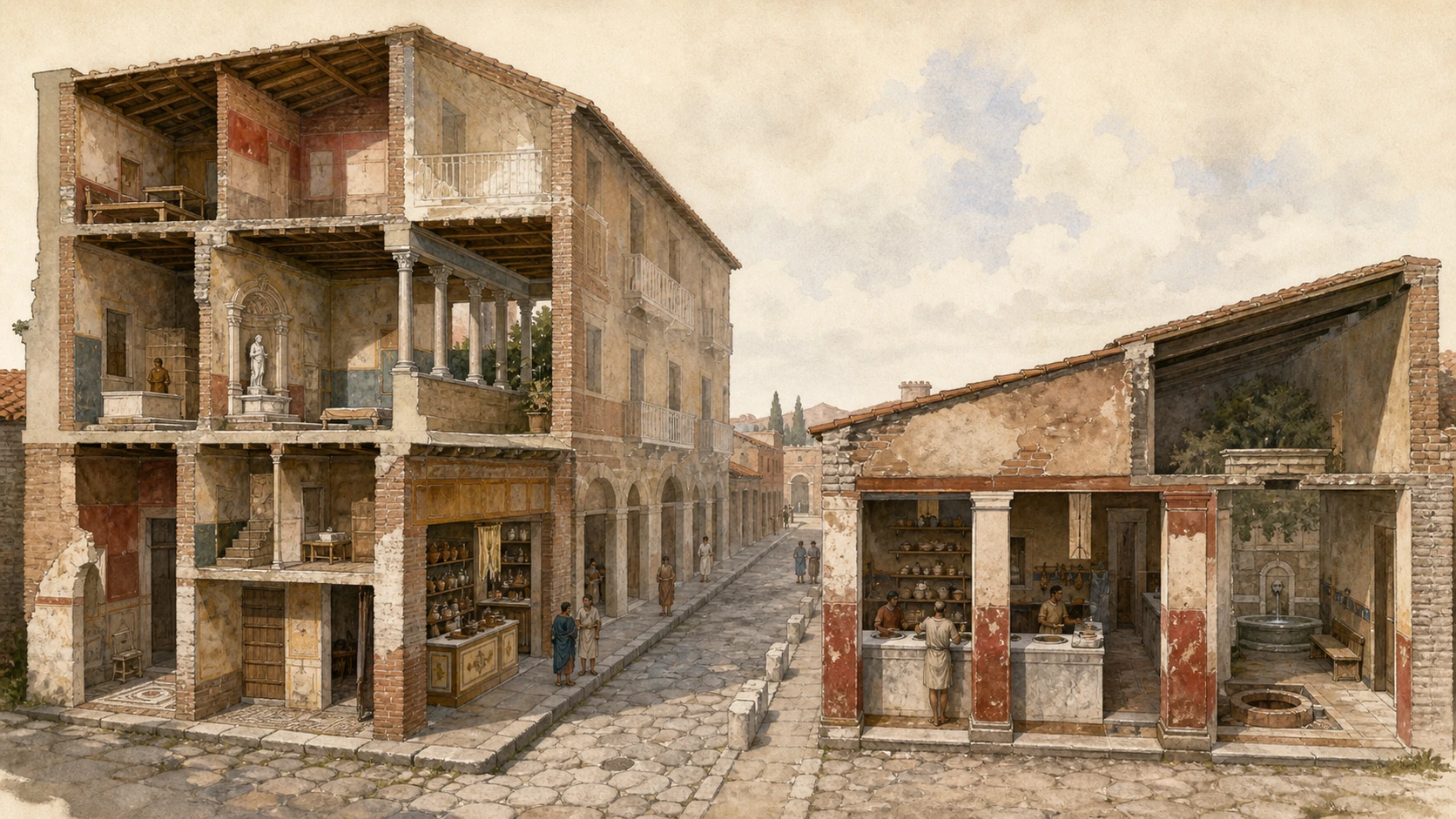
Casa di Diana preserves a porticoed courtyard, street shops, mosaic floors, traces of painted rooms and a marble nymphaeum within a block that may once have risen four storeys. Across Via di Diana, the thermopolium retains a masonry and marble serving counter, shelves, basins, kitchen space, a sunken dolium and a rear courtyard with seating and fountain. Balconies and upper walls visible today include major restorations, but they help recover the vertical street enclosure erased from much of the site.

History

The apartment complex was built in the Hadrianic period and altered repeatedly: floors rose, mosaics changed, rooms were subdivided and a Mithraic shrine was eventually installed deep inside. The inn and wine bar occupied part of another Hadrianic building in the third century. Still-life paintings advertised or evoked food and drink. These changes show property adapting to new tenants and uses rather than one ideal apartment plan surviving intact.

How to read this place

Thermopolium is a modern archaeological label useful for a food-and-drink business; it should not be translated automatically as fast food. The counter did not define the whole establishment, and dolia did not necessarily contain hot meals. Casa di Diana is an insula or apartment block, not the private House of a woman securely identified as Diana. Its conventional name derives from evidence within the complex, while original ownership and room functions remain partly uncertain.

What to notice

  • Shop openings and brackets indicating lost upper balconies
  • Courtyard nymphaeum inserted into an apartment complex
  • Bar counter, kitchen dolium and outdoor dining court forming a complete business
Archaeological Park of Ostia Antica · Casa di Diana
Original documentary watercolour street section of Casa di Diana and the Via di Diana thermopolium
Casa di Diana and the ThermopoliumOriginal Merlintravel documentary watercolour · 2026
06

Granaries, mills, bakeries and river craft converted Mediterranean harvests into Rome's daily bread

The grain system: horrea, mills and bakeries

Supply depended on storage, measurement, grinding, labour and transshipment rather than a single picturesque warehouse.

Today

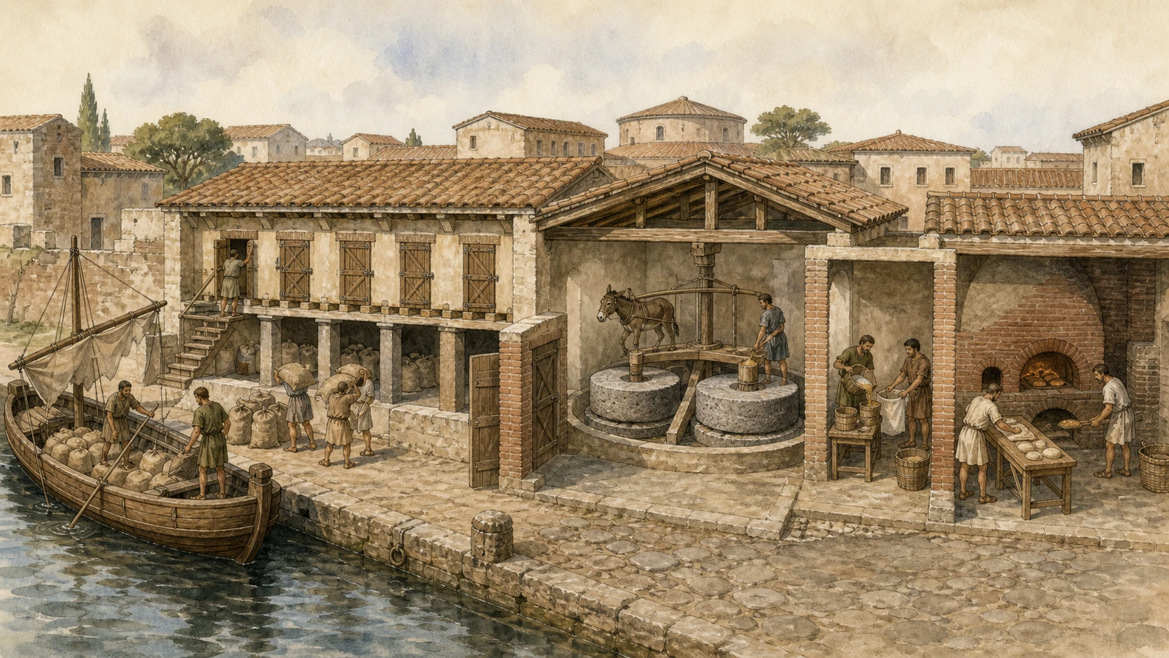
The Grandi Horrea, Horrea Epagathiana, grain measurers' buildings and mills occupy different parts of Ostia. Courtyards, raised storage floors, locking thresholds, millstones, kneading installations and ovens allow the chain to be reconstructed even when organic sacks and wooden equipment are gone. The Mill of Silvanus and Semita dei Cippi preserve dense working arrangements where animal-powered mills and ovens stood close to streets and housing. None is a complete industrial museum in situ; plans and wear patterns do much of the explanation.

History

Grain from Sicily, Sardinia, Egypt and North Africa reached Ostia and, increasingly from the first century AD, Portus aboard maritime cargo vessels. It was transferred to smaller boats for travel up the Tiber, stored in horrea, measured, milled and baked. Guilds, contractors and state officials overlapped in the annona, Rome's supply system. Three caudicariae preserved at Fiumicino provide rare hull evidence for the river stage represented schematically in Ostian mosaics.

How to read this place

Do not identify every warehouse as state grain storage: horrea held varied goods and could be privately managed. The famous decorated entrance of the Horrea Epagathiana signals security and status but not a known commodity. Millstones are not scattered sculpture; their paired volcanic stones formed machines. Keep workers in the story: porters, measurers, millers, bakers, animal handlers and boat crews connected imperial policy to daily food.

What to notice

  • Raised or ventilated storage arrangements protecting commodities
  • Volcanic millstones positioned for rotary animal power
  • Courtyards and controlled entrances organising movement and security
Archaeological Park of Ostia Antica · Grain and Bread trail
Original documentary watercolour cutaway of Ostian granaries, grain measurers, mills and bakery ovens
The grain system: horrea, mills and bakeriesOriginal Merlintravel documentary watercolour · 2026
07

A port community prayed, traded and adapted within a city of overlapping Jewish, traditional, imperial and mystery cults

The Synagogue and Ostia's religious plurality

The western Mediterranean's early synagogue belongs to the city, not to an isolated religious quarter beyond it.

Today

Near the ancient coast, the synagogue preserves an entrance sequence, prayer hall, bimah, Torah shrine, meeting space and an oven associated with unleavened bread. Menorah-decorated corbels make the identification secure. Elsewhere Ostia contains public temples, household shrines, Serapeum, Mithraea and late Christian evidence. These sites did not all flourish at the same time or with equal public visibility, but together they contradict a single uniform civic religion.

History

The synagogue originated around the middle of the first century AD and was substantially rebuilt in the fourth century, making it one of the oldest known synagogues in the western Mediterranean. Its scale reflects an established Jewish community connected with the port. Mithraea were inserted into houses and service complexes across the city, while late-antique Christian symbols and buildings appeared through reuse. The so-called Christian Basilica is now interpreted more cautiously as a late fourth-century domus with a Christogram and possible teaching or meeting rooms.

How to read this place

Do not treat every religious building as a sealed ethnic enclave. Port mobility could strengthen community institutions while sharing streets, water and work. The synagogue's fourth-century appearance should not be projected unchanged back to its first phase. Likewise, a Christogram does not automatically turn an entire house into a basilica. Distinguish secure architectural evidence, traditional names and current interpretation.

What to notice

  • Torah shrine oriented toward Jerusalem with menorah corbels
  • Bimah and benches organising communal reading and meeting
  • Later rebuilding preserving continuity while changing the plan
Archaeological Park of Ostia Antica · Synagogue
Original documentary watercolour reconstruction of Ostia's synagogue within a diverse port-city religious landscape
The Synagogue and Ostia's religious pluralityOriginal Merlintravel documentary watercolour · 2026
08

Gregoriopoli, Sant'Aurea and a Renaissance artillery castle replaced the abandoned port city with a smaller defended settlement

The Hamlet and Castle of Julius II

Post-antique Ostia is a historical continuation shaped by insecurity, papal customs and the river's changing course.

Today

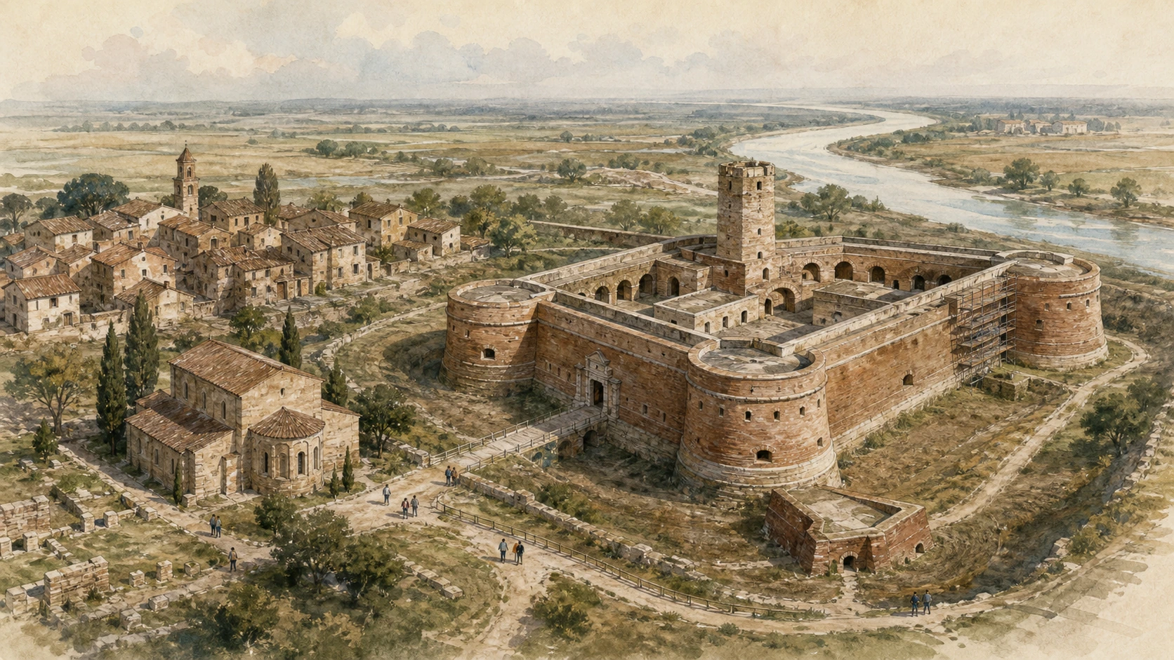
Across from the excavations, the small hamlet gathers around Sant'Aurea and the triangular brick castle. Baccio Pontelli's fortification combines a ditch, casemates, three towers, a ravelin and a broad internal spiral stair. Restorations may affect parts of the circuit, while access follows separate opening hours from the archaeological city. From the upper route, the distance between castle, ruins and current river makes the changed landscape easier to grasp.

History

By the mid-sixth century the ancient city was largely abandoned and settlement contracted inland. Pope Gregory IV fortified Gregoriopoli in the ninth century. Cardinal Giuliano della Rovere, the future Julius II, commissioned the castle in 1483 to control the river customs route. The 1556 siege and catastrophic 1557 flood undermined its strategic position as the Tiber shifted west; customs moved first to Tor Boacciana and later to Tor San Michele. The castle subsequently served as a prison connected with papal excavations.

How to read this place

The castle is Renaissance, not Roman, and its Julius II name reflects the patron's later papal identity rather than a construction during his pontificate. The hamlet did not simply occupy the empty ruins: it formed a separate fortified nucleus around Christian and medieval landmarks. The moat now reads dry and picturesque, but casemates, low firing positions and massive geometry answer gunpowder warfare. Check the current restoration route before promising panoramic access.

What to notice

  • Triangular artillery plan responding to angles of fire
  • Martin V's earlier tower incorporated into the later fortress
  • View showing how the present Tiber abandoned the castle's customs position
Archaeological Park of Ostia Antica · Castle and Hamlet
Original documentary watercolour of Ostia Antica's hamlet and Renaissance Castle of Julius II beside the displaced river landscape
The Hamlet and Castle of Julius IIOriginal Merlintravel documentary watercolour · 2026
09

Claudius and Trajan built sea-scale infrastructure; preserved hulls reveal the smaller craft that completed the route to Rome

Portus and the Roman Ships Museum

Basins, moles, warehouses, canals and boats made one logistical system whose coastline has moved far away.

Today

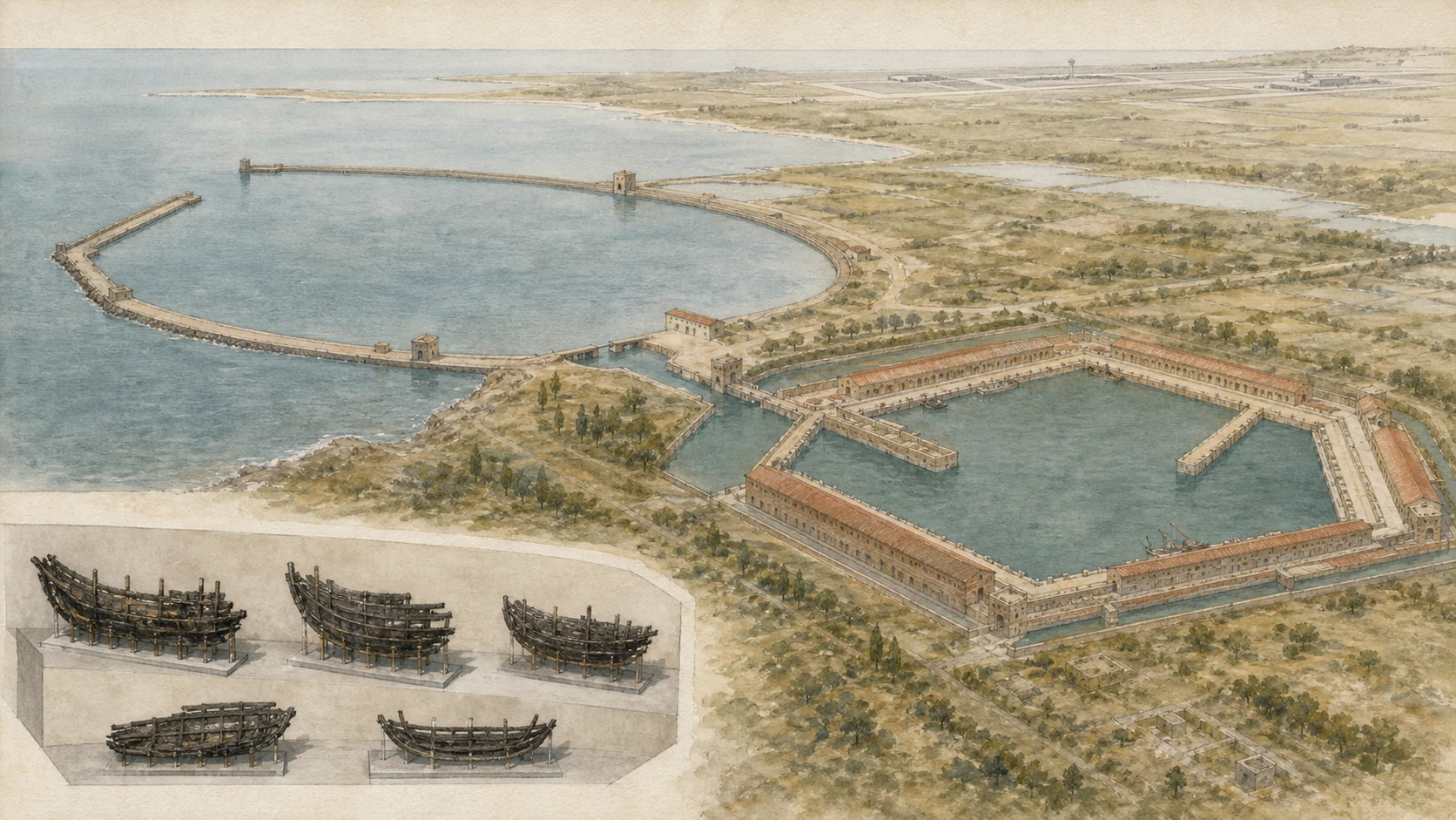
The archaeological area preserves sections of Claudius's harbour, Trajan's hexagonal basin, the Darsena, warehouses, roads and later Portus. Much of the ancient water surface is now lake, field or buried land, surrounded by airport and road infrastructure. The nearby Fiumicino museum displays five principal hulls: three river cargo boats, a seagoing vessel and a rare fishing boat with a live-fish tank. Conservation remains visible because ancient waterlogged wood is exceptionally fragile.

History

Claudius began a roughly 150-hectare basin in AD 42 with curved moles and a lighthouse on an artificial island. Trajan added the more sheltered hexagonal harbour around AD 110, linking basins and the Tiber through canals. Portus became an independent city in AD 314. The ship hulls were discovered between 1958 and 1965 during construction of Leonardo da Vinci Airport in the silted Claudian basin; the museum was built close to their findspot and reopened after major conservation work.

How to read this place

The hexagon is Trajanic, not the whole Portus, and the current lake is not a fully preserved Roman water level. Claudius's lighthouse has vanished; reconstructions remain hypotheses informed by archaeology and ancient descriptions. The caudicariae were cargo craft for river and short-sea transfer, not miniature ocean ships. Never touch or lean over conservation barriers: displaying the treated wood is an ongoing preservation experiment, not a finished restoration problem.

What to notice

  • Hexagonal geometry increasing sheltered quay frontage
  • Darsena and warehouses connecting large and small vessels
  • Hull construction and towing role of the caudicariae
Archaeological Park of Ostia Antica · Imperial Harbours
Original documentary watercolour aerial cutaway of Portus with Trajan's hexagonal basin, warehouses and preserved Roman river boats
Portus and the Roman Ships MuseumOriginal Merlintravel documentary watercolour · 2026
10

Tomb façades, professional images and a stranded river tower make the delta's communities and movement concrete

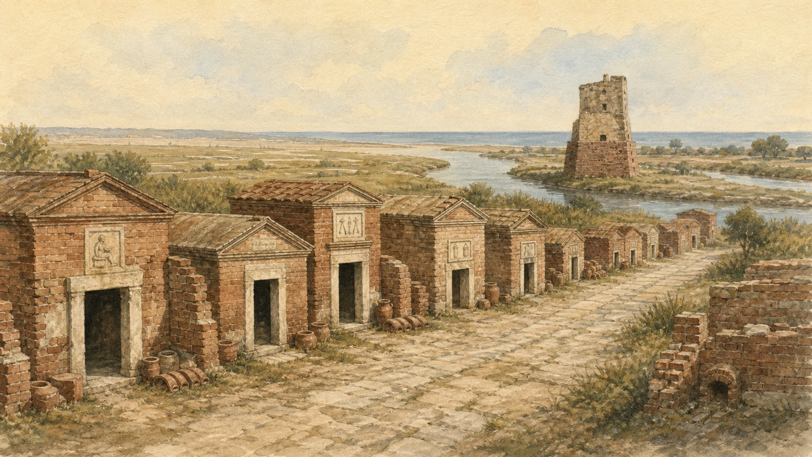
Isola Sacra, the Portus necropolis and Tor Boacciana

The burial road records a working middle class, while the tower marks a mouth that the river and sea have left behind.

Today

The Portus necropolis extends along the ancient Via Flavia on land formed between the Tiber and Fossa Traiana. More than two hundred burial structures create brick street fronts with inscriptions, painted and mosaic interiors, enclosures and later graves filling gaps. Across the delta landscape, Tor Boacciana stands on the left bank near the place where the imperial river reached the sea. The tower and some related sites may open only on special occasions; they should be understood from public viewpoints unless the Park announces access.

History

The necropolis developed from the late first to fourth centuries AD. Tomb owners included traders, freed people and small entrepreneurs; reliefs and plaques depict an obstetrician, surgeon, smith, grain merchant and other work. Cremation and inhumation overlapped as customs changed, while poorer burials occupied spaces between monumental cells. Tor Boacciana has a Trajanic base interpreted as a lighthouse or watchtower and a substantially medieval upper structure; it became a papal customs post after the 1557 flood displaced the river from Julius II's castle.

How to read this place

Isola Sacra is a delta formation, not an island eternally bounded by today’s channels. Professional reliefs are precious evidence but not a complete census of Portus society. Tor Boacciana’s ancient base, medieval rebuilding and later customs use are separate phases. The coast now lies far away because sediment advanced the shoreline, so the tower’s apparently inland position is evidence, not an error in the ancient account.

What to notice

  • Brick tomb façades and inscriptions creating a street of memory
  • Occupational images linking status to port labour and expertise
  • Ancient tower base stranded by river diversion and coastal advance
Archaeological Park of Ostia Antica · Portus necropolis
Original documentary watercolour of Isola Sacra's brick tomb road and Tor Boacciana beside the former Tiber mouth
Isola Sacra, the Portus necropolis and Tor BoaccianaOriginal Merlintravel documentary watercolour · 2026

The district through time

A short chronology

From the fourth-century BC castrum and imperial port city to Gregoriopoli, Portus, the Roman ship hulls and the altered Tiber mouth.

  1. Ancus Marcius is credited with founding Ostia at the salt-producing river mouth; archaeology does not confirm this date.

  2. A fortified Roman colony, the castrum, provides the earliest secure settlement evidence.

  3. A larger wall circuit and major sanctuaries accompany urban expansion beyond the castrum.

  4. Agrippa's theatre and the first form of the Square of the Guilds reshape the public river district.

  5. Claudius begins the immense maritime harbour north of the Tiber mouth.

  6. The Ostian synagogue is established and the Square of the Guilds receives its Claudian porticoes.

  7. Trajan adds the sheltered hexagonal basin at Portus.

  8. Hadrianic rebuilding monumentalises Ostia's Forum, Capitolium, housing and commercial blocks.

  9. The theatre expands to about four thousand spectators and many bath and residential complexes mature.

  10. An arch honouring Caracalla marks the theatre entrance on the Decumanus.

  11. Portus becomes an independent city, Portus Romae.

  12. Ancient Ostia is largely abandoned as population contracts inland.

  13. Gregoriopoli forms as a fortified settlement around Sant'Aurea.

  14. Giuliano della Rovere commissions Baccio Pontelli's artillery castle.

  15. A major flood diverts the Tiber and weakens the castle's customs and defensive role.

  16. Airport construction uncovers seven Roman hulls in the silted Claudian harbour basin.

Before your visit

Practical information

01

Do not overpack one day

Ostia's city alone rewards several hours; Portus, the ships, necropolis and castle have separate transfers and hours.

02

Check the mosaics

Protective winter covering and maintenance can hide celebrated pavements while leaving the architecture fully readable.

03

Carry water and shade

Long rough routes, summer heat and limited shelter make shoes, water and sun protection essential.

04

Use names critically

House, basilica, market and shrine names can be conventional archaeological labels rather than proven ancient ownership or function.

05

Restore the river mentally

Modern land, roads and airport conceal basins, coastline and channels; every district reads differently once water is put back.

06

Respect closed sectors

Restoration barriers, unstaffed towers and fragile tomb interiors are conservation limits, not invitations to find an unofficial entrance.

Method and sources

Sources and image credits

The guide uses current official material from the Archaeological Park of Ostia Antica, checked on 27 August 2026. It distinguishes literary foundation from archaeological evidence; republican castrum from the dominant imperial city; exposed brick core from ancient marble finish; theatre restoration from untouched survival; mosaic stationes from modern embassies; basilica as civic hall from Christian church; conventional building names from proven ownership; warehouses from grain-only storage; Ostia from Portus without an abrupt replacement myth; Trajan's hexagon from Claudius's harbour; treated ship hulls from complete vessels; a late-antique domus with Christogram from a secure basilica; Tor Boacciana's Roman base from its medieval tower; and the ancient coastline and Tiber channels from the modern delta.

All ten images are original Merlintravel editorial watercolours based on documented present-day conditions. They are illustrations, not substitutes for archaeological plans. Opening hours, tickets, accessible routes, temporary exhibitions and conservation work can change; consult the linked official pages shortly before visiting.