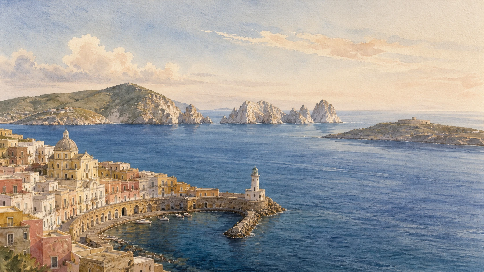
Original documentary watercolour panorama of the Pontine Islands joining Ponza harbour and volcanic cliffs with Palmarola, Zannone, Ventotene and Santo Stefano across open Tyrrhenian water

Lazio Guide 07 · Volcanic islands, engineered water and open-sea crossings

The Pontine
Islands

A documented route across Ponza, Palmarola, Zannone, Ventotene and Santo Stefano, where geology, navigation, Roman infrastructure and political exile remain inseparable.

Plan the route
Ponza · Palmarola · Zannone · Ventotene10 chapters · four to six days

Why this territory matters

The Pontine Islands are one archipelago on the map but not one continuous itinerary: geology, government and the sea divide them into different worlds.

The archipelago lies off the southern Lazio coast in two separated groups. Ponza, Palmarola and Zannone form the north-western group; Ventotene and Santo Stefano lie farther south-east. Their volcanic histories are not identical, and Zannone also exposes older metamorphic and sedimentary rocks. The distances between the groups are large enough that a traveller should not imagine a chain of easy island hops. Ponza and Ventotene are the inhabited bases; the smaller islands require authorised boats, suitable sea conditions or both.

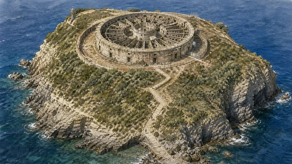
Human settlement repeatedly solved the same island problems in different political languages. Roman villas depended on cisterns, aqueducts, ports and fishponds. Eighteenth-century Bourbon projects redesigned Ponza’s harbour and built the extraordinary circular prison on Santo Stefano. In the twentieth century, confinement turned the archipelago into a geography of political memory: Ventotene became inseparable from the anti-fascist manifesto drafted there, while Santo Stefano preserves the harsher material history of incarceration.

Access cannot be reduced to a ferry ticket. Chiaia di Luna is a protected and unstable shore to be observed from safe public viewpoints or from the sea under current restrictions, not advertised as an ordinary beach. Zannone has a demanding trail and a landing where boats cannot remain. Palmarola depends on weather and local boat operation. Villa Giulia, the Roman cisterns and Santo Stefano use guided calendars; the marine protected area has its own rules. The correct route is therefore built around two bases, verified conditions and generous weather margins.

Read every harbour as infrastructure, every cove as geology, and every crossing as a condition rather than a promise.

The route

Plan your visit

Use Ponza and Ventotene as separate bases instead of treating the archipelago as a linear ferry itinerary. Build days around official guided openings and same-day marine conditions. The sequence below keeps the major cultural chapters reachable even when a small-island landing is cancelled.

Days one and two

Ponza harbour, Roman water and Chiaia di Luna

Walk the Bourbon harbour and town, then book the Dragonara cistern or another managed archaeological visit. Read Chiaia di Luna from the public belvedere and the Roman tunnel only where access is explicitly permitted.

Day three

Ponza by sea and Palmarola

Choose a licensed local excursion only after checking wind, swell and landing conditions. Grotte di Pilato and Palmarola make sense as volcanic and archaeological coastlines, not as guaranteed swimming stops.

Day four or substitute

Zannone trail

Reserve a boat from Ponza, confirm that landing is operating and carry everything needed for a difficult exposed walk. If the crossing fails, use Ponza’s port, cisterns and upland paths as the replacement day.

Days five and six

Ventotene and Santo Stefano

Give the Roman port, fishpond, Villa Giulia and the island’s political memory a full day. Add Santo Stefano only with the official limited visit, advance booking, closed shoes and favourable sea and worksite conditions.

Ten chapters

Explore the places

The chapters cross two island groups from geology and engineered water to political memory. Use the index without confusing a visible coast, a legal landing and a guaranteed visit.

  1. 01An archipelago divided by geology and distance
  2. 02Ponza harbour: the Bourbon town as infrastructure
  3. 03The Dragonara and Ponza’s Roman water network
  4. 04Chiaia di Luna: admire the bay without claiming the beach
  5. 05The Grotte di Pilato as Roman fishponds
  6. 06Palmarola: a volcanic island read from the water
  7. 07Zannone: one demanding trail, not a casual beach stop
  8. 08Ventotene: the Roman port and Peschiera
  9. 09Villa Giulia and Ventotene’s landscape of exile
  10. 10Santo Stefano: the panopticon prison and a controlled landing
01

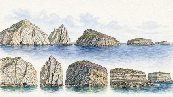
Five major islands form two separated groups whose rocks record different volcanic episodes and a more complicated foundation beneath Zannone

An archipelago divided by geology and distance

The Pontine Islands should be understood as two geological groups across open water, not as fragments of one collapsed volcano.

Today

Ponza, Palmarola and Zannone rise north-west of the Ventotene–Santo Stefano group. From the water, the western islands show pale, folded and vividly altered volcanic cliffs, domes, dykes and sea-cut stacks. Ventotene and Santo Stefano present darker, more regular volcanic plateaux and layered coastal sections. Zannone is the exception that complicates any simple volcanic label: older metamorphic and sedimentary units crop out beneath volcanic products. The sea between the groups is part of the landscape and determines whether a planned route is realistic.

History

ISPRA distinguishes the older western volcanic activity, developed from the late Pliocene into the early Pleistocene, from the younger eastern activity of Ventotene and Santo Stefano. Ponza and Palmarola preserve the remains of rhyolitic and trachytic domes formed in submarine and subaerial environments. The eastern islands developed from a separate volcanic apparatus in the Gulf of Gaeta. Erosion, faulting, changing sea level and continuing marine action produced the cliffs and small coves visible today.

How to read this place

Avoid saying that every coloured band is lava or that the five islands are the rim of one crater. Tuffs, lava domes, intrusive bodies, altered volcanic deposits and older basement rocks require different explanations. The most useful first observation is comparative: Ponza’s irregular pale architecture, Palmarola’s exposed domes, Zannone’s mixed foundation and Ventotene’s layered plateau. This geological difference explains coast form, landing difficulty, building stone and the radically different experience of each island.

What to notice

  • Two island groups separated by a substantial open-sea passage
  • Pale domes and altered volcanic cliffs in the western group
  • Darker layered plateau edges around Ventotene and Santo Stefano
ISPRA · Geological Sheet 413 Borgo Grappa
Original documentary watercolour geological panorama comparing the pale volcanic domes of Ponza and Palmarola with Zannone's mixed rocks and the layered plateaux of Ventotene and Santo Stefano
An archipelago divided by geology and distanceOriginal Merlintravel documentary watercolour · 2026
02

A late eighteenth-century harbour project combined defence, administration, worship, housing and water control into one theatrical working waterfront

Ponza harbour: the Bourbon town as infrastructure

The curved waterfront is not a spontaneous Mediterranean postcard but the visible core of a coordinated Bourbon settlement project.

Today

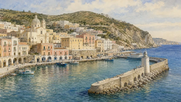
Arriving ferries enter a harbour framed by a long curving line of coloured façades, former warehouses, ramps and the domed church of Santi Silverio e Domitilla. The semicircular waterfront still functions as transport interchange, fishing port, commercial street and civic threshold. Behind the picturesque surface, changes of level reveal rock-cut spaces, drainage routes and the pressure of building a capital for an island with very little flat ground. The municipal palace and the former governor’s buildings preserve the administrative face of the project.

History

The Bourbon government repopulated Ponza in the eighteenth century and recognised that agriculture alone could not sustain the colony without a new port and civic centre. Major Antonio Winspeare and engineer Francesco Carpi designed the harbour settlement. Work began in the 1770s and the port became fully operational in 1779, with a rebuilt mole, defensive battery, lighthouse, warehouses, military and penal quarters, church and governmental buildings. The project reused the ancient harbour position while imposing a new monumental and functional order.

How to read this place

Do not detach the coloured houses from the mole, warehouses and water management. The scenographic curve is also a machine for landing people and goods, controlling runoff and representing royal authority. Follow the sequence from the lighthouse and mole to the lower storage arches, upper dwellings, church and civic buildings. The best reading moves slowly around the basin before climbing above it; only then does the relationship between harbour engineering and urban form become clear.

What to notice

  • Curved mole and waterfront enclosing the arrival basin
  • Lower warehouse rhythm beneath upper residential façades
  • Church, government buildings and former military spaces within one planned centre
Comune di Ponza · historical itinerary
Original documentary watercolour of Ponza's Bourbon harbour showing the curved mole, lighthouse, lower warehouses, coloured houses and domed church as one working urban composition
Ponza harbour: the Bourbon town as infrastructureOriginal Merlintravel documentary watercolour · 2026
03

Large rock-cut reservoirs reveal how Roman elite architecture depended on a distributed hydraulic system rather than on monumental rooms alone

The Dragonara and Ponza’s Roman water network

Ponza’s cisterns are architectural interiors and evidence of a larger aqueduct-and-storage system built for an island without dependable surface water.

Today

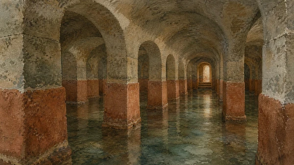
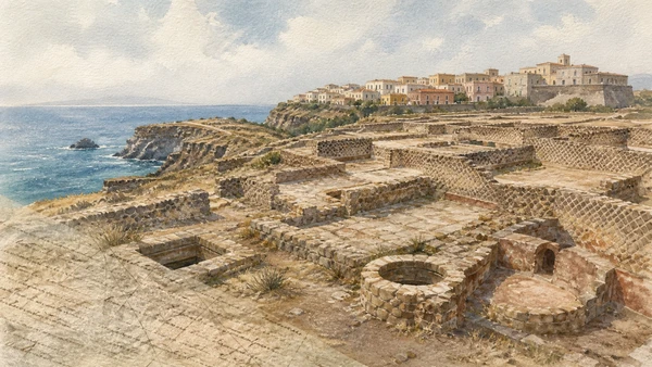
The Cisterna della Dragonara lies within the town above the harbour and is the most accessible point for understanding Ponza’s Roman water engineering when managed visits are operating. A grid of passages and piers carries the vaults; hydraulic lining survives on the walls. Other reservoirs at Via Parata, Punta della Madonna, Santa Maria and Grotta del Serpente belong to a distributed system and do not share one access status. Some are visitable only by arrangement, visible only in part or closed. Current municipal or local guided information must govern entry.

History

Roman settlement expanded the island’s capacity through an aqueduct and numerous cisterns cut or built into volcanic rock. Rainwater and spring water were collected, conveyed and stored near residential and harbour zones. The Dragonara’s regular interior allowed a large volume to be supported beneath the urban fabric. These reservoirs served villas, baths and everyday occupation; they were later reused, modified or incorporated into newer buildings. Their survival records continuity of need even when political control changed.

How to read this place

Avoid presenting one cistern as an isolated underground curiosity. Look for settling arrangements, waterproof cocciopesto, changes in masonry and the relationship between roof level and streets above. Access restrictions protect confined spaces and are not interchangeable: a historic guide’s symbol is not proof that a door is open today. Book the Dragonara through the current local channel and use the other reservoirs to map the scale of the network rather than to improvise unauthorised entry.

What to notice

  • Orthogonal galleries and piers distributing the weight of the vaults
  • Waterproof wall lining and rounded junctions designed for storage
  • Position above the harbour linking reservoir, urban fabric and Roman settlement
Comune di Ponza · archaeological guide
Original documentary watercolour inside the Cisterna della Dragonara showing its grid of rock-cut passages, masonry piers, vaulted roof and surviving hydraulic lining
The Dragonara and Ponza’s Roman water networkOriginal Merlintravel documentary watercolour · 2026
04

A Roman access tunnel opens toward a monumental cliff and bay whose instability now sets strict limits on how the landscape can be experienced

Chiaia di Luna: admire the bay without claiming the beach

Chiaia di Luna is a geological and archaeological viewpoint, not an ordinary bathing destination, and current safety restrictions take precedence over old descriptions.

Today

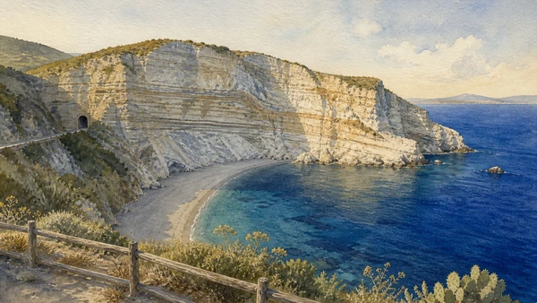
The sweeping bay is best understood from the public belvedere above or from a boat remaining outside restricted water and cliff zones. The pale crescent cliff is spectacular precisely because erosion is active; rockfall risk has led to long-standing interdiction of the beach and control of the Roman tunnel. Official national tourism information describes the shore as closed and visible only from the sea at a safe distance. Local barriers, ordinances and maritime notices must be obeyed even when older websites still advertise access.

History

A Roman tunnel cut through the ridge linked the harbour side of Ponza with the western bay. Its galleries and construction show that Chiaia di Luna belonged to the island’s engineered communication system, not merely to modern beach culture. The cliff exposes sequences of volcanic deposits shaped by marine erosion. Later reuse and repairs altered the passage. Modern accidents and slope instability transformed access, making geological process and public safety central to the site’s present meaning.

How to read this place

Do not cross a gate, descend an informal path or treat a calm sea as evidence that the cliff is safe. Separate three things often conflated online: the existence of the ancient tunnel, the visibility of the bay and legal access to the beach. A responsible account can fully explain the tunnel and coastal formation without entering the prohibited shore. Photograph the complete crescent from above; it gives a clearer reading of the cliff layers and engineered approach than a beach-level image would.

What to notice

  • High crescent cliff exposing layered volcanic deposits
  • Tunnel alignment through the ridge toward the harbour side
  • Safety perimeter demonstrating that erosion is an active process
Italia.it · Chiaia di Luna current access warning
Original documentary watercolour from the safe public belvedere above Chiaia di Luna showing the crescent volcanic cliff, closed shore and Roman tunnel alignment without people on the beach
Chiaia di Luna: admire the bay without claiming the beachOriginal Merlintravel documentary watercolour · 2026
05

Rock-cut marine basins beside Punta della Madonna join elite Roman leisure, aquaculture and the controlled movement of seawater

The Grotte di Pilato as Roman fishponds

The grottoes are a designed coastal installation associated with a Roman villa, not natural caves carrying proof of the Pilate legend.

Today

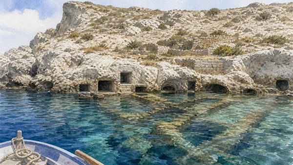
From the sea near Punta della Madonna, openings and channels reveal a complex of excavated basins at the waterline. Visits are normally approached by local boat and remain dependent on swell, operator practice and current maritime restrictions. Even in calm weather, the rock-cut rooms are fragile and should not be treated as a free swimming cave. Nearby remains of the Roman villa occupy the headland above, while later harbour and military use changed the coastal setting.

History

The fishpond complex was created around the late first century BC and early first century AD. Connected tanks and channels refreshed seawater and separated species prized by wealthy Roman households. Decorative traces suggest that productive and recreational uses were combined within a maritime villa landscape. The traditional name links the caves with Pontius Pilate, but that association is not archaeological evidence. In the Bourbon period the spaces were adapted as stores and shelters for small craft.

How to read this place

Read water movement before legend. Identify the relationship between external sea, channels, enclosed basins and the villa terrace rather than imagining one grotto. Boat position changes what can be seen, so no excursion should promise entry into every chamber. The most honest image keeps the viewer outside the openings and shows the cut geometry at the tide line. Use the traditional name as cultural memory while clearly labelling the Roman aquaculture interpretation as the evidence-based explanation.

What to notice

  • Cut openings arranged as a system rather than isolated natural caves
  • Channels connecting seawater with internal basins
  • Punta della Madonna terrace rising above the fishpond complex
Comune di Ponza · Grotte di Pilato
Original documentary watercolour from a small boat outside the Grotte di Pilato showing Roman-cut fishpond openings, connecting channels and Punta della Madonna above
The Grotte di Pilato as Roman fishpondsOriginal Merlintravel documentary watercolour · 2026
06

An almost uninhabited island of domes, dykes, sea stacks and one conditional landing makes geology more reliable than a beach checklist

Palmarola: a volcanic island read from the water

Palmarola’s route is a circumnavigation shaped by sea conditions, with landing and swimming always secondary to safe observation.

Today

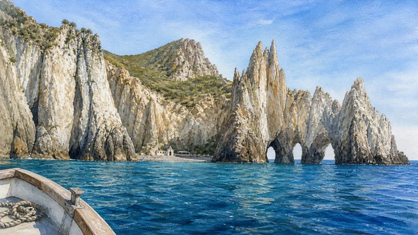
Palmarola lies more than seven nautical miles from Ponza and is reached by local excursion boats when conditions permit. Pale cliffs, dark dykes, the Cathedral-like rock forms, sea caves and stacks create a constantly changing profile. Cala di San Silverio is the principal landing named by regional tourism information, but shore access and boat stops remain conditional. The island is largely uninhabited; limited seasonal activity does not turn it into a serviced destination or guarantee water, shade, rescue or return at a fixed time.

History

Submarine and later exposed volcanic processes built rhyolitic domes and deposits that erosion separated into ridges and stacks. Obsidian from Palmarola circulated in prehistory, evidence that the island entered Mediterranean networks long before modern tourism. Small chapels, cave shelters, fishing and seasonal use created a sparse human layer without producing a continuous town. The name is traditionally associated with the dwarf palm that survives on the island, an element of its distinctive vegetation.

How to read this place

Do not write a fixed clockwise itinerary independent of wind. The same western wall that is calm under one forecast can become untenable under another. Ask the operator what the sea permits that day and accept a changed route. From the boat, distinguish vertical dykes from lighter host deposits and human cave fronts from natural cavities. Landing is not the measure of success: a careful offshore reading often protects both visitor and fragile shore while revealing more geology.

What to notice

  • Pale volcanic walls cut by darker resistant dykes
  • Cathedral-like stacks and arches shaped by differential erosion
  • Sparse cave shelters and the small San Silverio landing within a largely uninhabited coast
Visit Lazio · Palmarola
Original documentary watercolour from offshore Palmarola showing pale volcanic cliffs, dark dykes, Cathedral-like stacks, dwarf palms and the small conditional landing at Cala San Silverio
Palmarola: a volcanic island read from the waterOriginal Merlintravel documentary watercolour · 2026
07

The archipelago’s only island inside the Circeo National Park combines a difficult landing, Mediterranean scrub, monastery ruins and a remote lighthouse

Zannone: one demanding trail, not a casual beach stop

Zannone requires a dedicated boat and an expert-grade out-and-back walk whose official status and landing conditions must be confirmed before departure.

Today

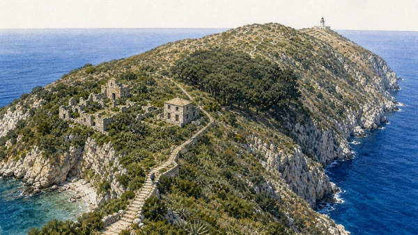
The Circeo National Park lists the Zannone trail as open: about two kilometres from Caletta del Varo to the lighthouse, ninety minutes one way, 194 metres of ascent and difficulty EE for experienced hikers. Boats reach the island from Ponza but cannot remain at the landing. Steps climb through Mediterranean scrub toward the ruins of a Benedictine monastery and the former hunting lodge, which the park states is not accessible. The route continues through holm oak woodland and across exposed high ground to the lighthouse before returning the same way.

History

Zannone preserves geological units older and more varied than the purely volcanic image of the archipelago suggests. A monastic settlement traditionally dated to the early medieval period occupied the island before insecurity and isolation contributed to abandonment. Later hunting use introduced buildings and mouflon. In 1979 Zannone became part of the Circeo National Park, shifting management toward conservation while leaving the island dependent on external boats and without the services of an inhabited destination.

How to read this place

The word open is not a guarantee that a boat can land today. Confirm the park notice, operator, return arrangement, weather and physical requirements together. Carry water, sun protection and suitable footwear; there is no town at the far end. Do not enter the former hunting lodge or invent a circular route when the official itinerary returns along the same path. The strongest reading contrasts scrub, shaded holm oak, monastic ruins and the exposed lighthouse edge.

What to notice

  • Stepped ascent beginning immediately above Caletta del Varo
  • Monastery ruins and inaccessible former hunting lodge on the high ground
  • Holm oak woodland giving way to an exposed lighthouse approach
Circeo National Park · Zannone trail
Original documentary watercolour of Zannone's official trail climbing from Caletta del Varo through scrub past monastery ruins and holm oaks toward the remote lighthouse
Zannone: one demanding trail, not a casual beach stopOriginal Merlintravel documentary watercolour · 2026
08

A compact harbour carved into volcanic tuff and a sophisticated fishpond show how Roman engineering turned a small island edge into infrastructure

Ventotene: the Roman port and Peschiera

The ancient harbour is still a lived maritime threshold, while the nearby fishpond clarifies the productive engineering behind imperial island life.

Today

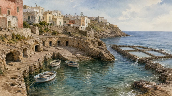
Ventotene’s Porto Romano remains immediately legible beneath the Bourbon town: ramps, bollard cuttings, rock-cut stores and the protected basin are integrated into daily arrivals. Near Punta Eolo, the Peschiera Romana uses chambers and channels cut into the tuff to maintain circulating seawater. Observation must respect slippery rock, waves and any local enclosure. The modern ferry uses a different basin, allowing the ancient harbour to retain a smaller scale while still functioning for boats and waterfront movement.

History

Roman engineers excavated and finished the harbour within the island’s volcanic edge, creating a protected landing connected to storage, water and the imperial villa above. The fishpond was divided into three main sectors and designed with channels, shaded areas and internal features suitable for valuable marine species. These works belonged to a larger system of cisterns, aqueducts and residential terraces that supported elite occupation and later exile on an island with limited natural resources.

How to read this place

The cavities and harbour walls include structures from different periods as well as natural features. Tool marks, cut faces and controlled alignments distinguish infrastructure from natural erosion. In the fishpond, look for water circulation and separation rather than an aquarium reconstructed in the imagination. In the port, connect the low rock-cut rooms with ramps to the Bourbon settlement above. Ventotene’s small scale makes these historical layers physically close, but their dates and purposes must remain distinct.

What to notice

  • Rock-cut basin and ramps organising the ancient harbour
  • Mooring and storage traces integrated into the present waterfront
  • Three-part fishpond with channels maintaining exchange with the sea
Comune di Ventotene · Roman fishpond
Original documentary watercolour of Ventotene's Roman harbour with rock-cut ramps and stores continuing toward the nearby tripartite Peschiera Romana at Punta Eolo
Ventotene: the Roman port and PeschieraOriginal Merlintravel documentary watercolour · 2026
09

An Augustan maritime residence became a place of dynastic exile, while the later island of confinement produced a radically different European political memory

Villa Giulia and Ventotene’s landscape of exile

Villa Giulia and the twentieth-century confino belong to separate regimes, yet together they explain how distance made Ventotene both residence and instrument of control.

Today

The archaeological area of Villa Giulia occupies Punta Eolo above the arrival coast, with terraces, rooms, gardens, cisterns and baths spread across a large exposed site. Current local information schedules accompanied visits rather than unrestricted entry, and the MiC page requires booking even though its displayed weekly timetable is not a reliable live calendar. In the town, the museum and public memory of the anti-fascist confino connect Ventotene with Altiero Spinelli, Ernesto Rossi, Eugenio Colorni and the 1941 federalist text known as the Ventotene Manifesto.

History

The villa was built at the end of the first century BC for the imperial family and soon became associated with the exile of Julia, Augustus’s daughter, followed by other Julio-Claudian women. Its luxury and coercive isolation were not opposites: controlled access made both possible. Under Fascism, Ventotene held political opponents in a very different settlement of confinement. In 1941 Spinelli and Rossi drafted a manifesto for a free and united Europe, circulated through clandestine networks and later linked with European federalism.

How to read this place

Avoid collapsing two millennia of exile into one continuous institution. The imperial villa, Bourbon town, Fascist confinement settlement and modern European memory have different structures and actors. At Punta Eolo, read terraces and sea control before famous names. In town, use documented places and museum material rather than a generic claim that the European Union was founded here. The manifesto is a foundational federalist text, not a constitutional act, and its power comes from being written under confinement.

What to notice

  • Long villa terraces adapted to the volcanic plateau and eastern light
  • Cisterns, baths and service areas supporting an isolated elite residence
  • Town spaces where twentieth-century confinement and federalist memory are interpreted
Ministero della Cultura · Villa Giulia, Ventotene
Original documentary watercolour of Villa Giulia's archaeological terraces on Punta Eolo with Ventotene town beyond and a restrained archival layer evoking the 1941 federalist manifesto
Villa Giulia and Ventotene’s landscape of exileOriginal Merlintravel documentary watercolour · 2026
10

A circular Bourbon prison dominates an uninhabited protected island where every modern visit is constrained by landing, safety works and conservation

Santo Stefano: the panopticon prison and a controlled landing

The former prison is a powerful monument, but it remains an active recovery site reached only through limited official visits from Ventotene.

Today

Santo Stefano has no ordinary harbour, permanent population, water or electricity. Its circular former prison rises above a difficult landing within the state nature reserve and marine protected area. For 2026, the managing authority announced guided visits under municipal Ordinance 27/2026 through 30 September, on specified days and with mandatory booking through the visitor centre. Numbers are limited; closed shoes and physical fitness are essential; sea conditions, fire prevention, worksite requirements and the guide’s decision can cancel or change the programme.

History

Ferdinand IV commissioned the prison in the late eighteenth century, using a radial plan around a central observation point. Opened under Bourbon rule, it later held political prisoners, anti-fascists and ordinary inmates under successive states. Luigi Settembrini and, much later, Sandro Pertini were among its prisoners. The institution closed in 1965. Decades of abandonment followed, while the building’s form and the testimonies of confinement gave it national and European significance. A major public recovery programme now addresses safety, conservation and future cultural use.

How to read this place

Restoration remains in progress, and the proposed museum belongs to a later phase of the project. The official project anticipates fuller operation later, but the current experience remains a controlled route through a fragile island and active works. Read the radial cell blocks, central control position and enclosing wall as architecture of surveillance, then relate them to prisoners’ documented lives. A cancelled landing is not a failed day: Ventotene’s port, museums and confinement landscape supply the necessary context.

What to notice

  • Circular prison wall and radial blocks centred on surveillance
  • Steep path separating the landing from the prison plateau
  • Protective works and controlled visitor route within an uninhabited reserve
Ventotene–Santo Stefano Reserve · 2026 guided visits
Original documentary watercolour from above Santo Stefano showing the circular Bourbon prison, radial cell blocks, steep landing path and controlled conservation worksite
Santo Stefano: the panopticon prison and a controlled landingOriginal Merlintravel documentary watercolour · 2026

The Pontine Islands through time

A short chronology

From separate volcanic systems and Roman infrastructure to Bourbon settlement, political confinement, protected waters and the access conditions of 2026.

  1. Volcanic activity builds the principal structures of Ponza, Palmarola and the western Pontine group.

  2. The younger eastern volcanic system forms Ventotene and Santo Stefano.

  3. Palmarola obsidian circulates through wider central Mediterranean exchange networks.

  4. Imperial building at Ventotene and major maritime works at Ponza organise villas, ports, cisterns and fishponds.

  5. Julia, daughter of Augustus, is confined on Ventotene, traditionally associated with Villa Giulia.

  6. Ponza’s Grotte di Pilato fishpond complex operates within a Roman maritime villa landscape.

  7. A monastic settlement develops on Zannone before later abandonment.

  8. Bourbon colonisation and infrastructure reshape Ponza’s inhabited landscape.

  9. Winspeare and Carpi’s harbour works give Ponza Porto its monumental and functional form.

  10. Construction begins on the radial prison complex on Santo Stefano.

  11. The Santo Stefano prison enters service under Bourbon rule.

  12. The Fascist regime uses Ventotene for the confinement of political opponents.

  13. Spinelli and Rossi draft the federalist text later known as the Ventotene Manifesto.

  14. The Santo Stefano prison closes after more than a century and a half of operation.

  15. Zannone becomes part of the Circeo National Park.

  16. Protected-area rules, guided calendars and active conservation works make verified access central to every island crossing.

Before your visit

Practical information

01

Use two bases

Ponza and Ventotene belong to separated island groups; do not build the route around a casual same-day connection between them.

02

Keep one reserve day

Wind and swell can cancel Palmarola, Zannone or Santo Stefano even when the mainland ferry has operated.

03

Do not enter Chiaia di Luna

Treat the bay as a safe-viewpoint and offshore interpretation chapter unless a new competent-authority notice explicitly changes access.

04

Book archaeology locally

Dragonara, Ventotene’s cisterns and Villa Giulia use managed or accompanied access that can change after publication.

05

Prepare for Zannone

The official route is graded EE, returns along the same path and begins at a landing where the boat cannot wait.

06

Treat Santo Stefano as conditional

The 2026 visit is limited, booked and subject to sea, safety and worksite conditions; it is not an ordinary ferry destination.

Method and sources

Sources and image credits

The guide uses current official or institutional information from ISPRA, the Comune di Ponza, Italia.it, Visit Lazio, the Circeo National Park, the Comune di Ventotene, the Italian Ministry of Culture, the Ventotene–Santo Stefano state reserve and marine protected area, and the Government commissioner for Santo Stefano, checked on 27 August 2026. It distinguishes the western and eastern geological groups; volcanic deposits from older Zannone basement; a traditional place name from archaeological evidence; visibility from legal access; a boat excursion from a guaranteed landing; an official open trail from same-day marine feasibility; Roman exile from Fascist confinement; a foundational federalist text from a constitutional act; a 2026 guided visit from a completed museum; and a future operating target from present visitor conditions.

All ten images are original Merlintravel editorial watercolours based on documented present-day conditions. They are illustrations, not substitutes for archaeological plans. Opening hours, tickets, accessible routes, temporary exhibitions and conservation work can change; consult the linked official pages shortly before visiting.