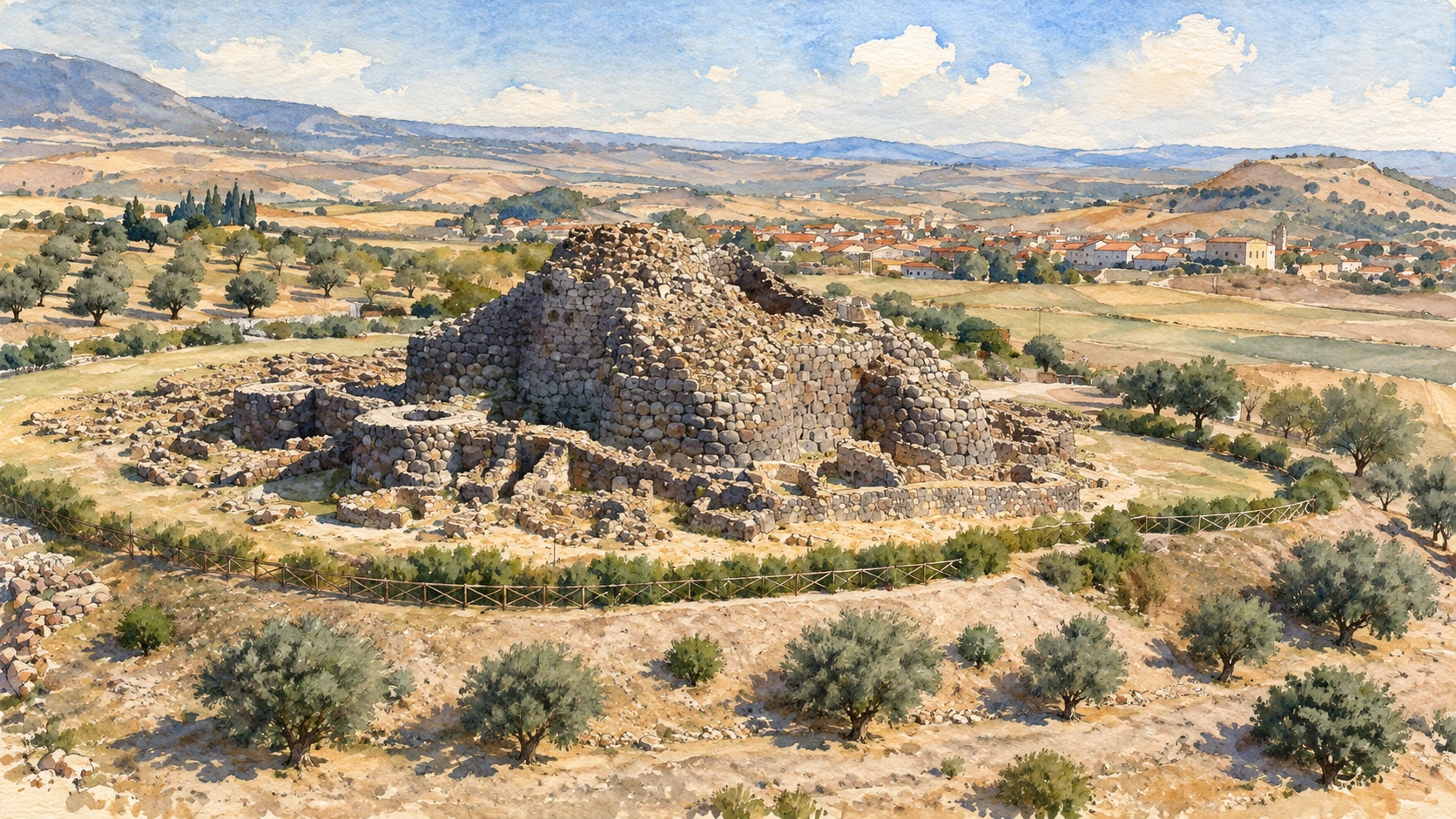
Watercolour: Su Nuraxi and Barumini establishing view

Sardinia · Guide 02

Barumini

Nuragic towers, a palace built over archaeology and the living landscapes of the Marmilla give depth to a journey beyond the coast.

Plan the route
Su Nuraxi and Barumini10 chapters · history, culture and landscape

Why this place matters

Begin with the stones, then widen the landscape.

Su Nuraxi is the starting point for a territory, not an isolated monument. Its towers and houses preserve successive building campaigns, while the nearby museums explain both excavation and interpretation. Casa Zapata adds an unexpected vertical relationship between a later residence and prehistoric masonry beneath it. Beyond Barumini, Tuili, the Giara, Las Plassas and Siddi introduce different distances and different kinds of visit. Allow separate outings rather than treating every chapter as a stop on one continuous walk.

The guide separates documented history from suggestions for reading the site. Named buildings and landscape relationships follow institutional sources; the illustrations are editorial interpretations, not measured surveys or records of current access.

Nuragic towers, a palace built over archaeology and the living landscapes of the Marmilla give depth to a journey beyond the coast.
The route

Plan your visit

Combine the guided visits at Su Nuraxi, Casa Zapata and Centro Giovanni Lilliu according to the foundation’s current arrangements. The tower and village chapters are parts of the same Su Nuraxi visit, not separate tickets. Tuili and the Giara require a separate excursion; Las Plassas and Siddi add further transfers. Check heat notices and the route actually available before departure.

Su Nuraxi

Complex, central tower and village

Combine the guided visits at Su Nuraxi, Casa Zapata and Centro Giovanni Lilliu according to the foundation’s current arrangements.

Barumini museums

Casa Zapata, Nuraxi ’e Cresia and Lilliu

Plateau excursion

Tuili and the Giara

Wider Marmilla

Las Plassas and Siddi

Ten chapters

Explore the places

The chapters connect history and terrain. Use the route notes to choose visits and plan transfers between separate sites.

  1. 01Su Nuraxi: a complex built in stages
  2. 02Inside the central tower
  3. 03The village: houses and shared space
  4. 04Casa Zapata: a residence becomes a museum
  5. 05Nuraxi ’e Cresia beneath the palace
  6. 06Centro Giovanni Lilliu: how ruins are interpreted
  7. 07San Pietro at Tuili
  8. 08The Giara: seasonal water and free-ranging horses
  9. 09Las Plassas and the castle hill
  10. 10Sa Domu ’e s’Orku at Siddi
01

Evidence and interpretation

Su Nuraxi: a complex built in stages

The aerial view makes the relationship between the massive tower compound and the surrounding settlement immediately visible. At ground level, walls, passages and changing levels reveal how much more complicated the site is than a single freestanding tower.

Today

Visits are guided. The foundation may alter the route or timetable because of weather and heat; confirm the current arrangements directly. Uneven stone surfaces and narrow passages require an individual assessment of accessibility.

History

Construction began in the Bronze Age and developed through several phases. A central tower became the core of a compound with four subsidiary towers; further defensive works and domestic buildings changed its surroundings. Excavations led by Giovanni Lilliu in the 1950s exposed the monument, which entered the UNESCO World Heritage List in 1997.

How to read this place

Begin with the guide’s explanation of the plan before following the permitted route. The original height of a tower is not its surviving height. The aerial watercolour is an orientation study of present ruins, not an archaeological reconstruction or a visitor viewpoint available on foot.

What to notice

  • Begin with the guide’s explanation of the plan before following the permitted route.
  • The original height of a tower is not its surviving height.
  • The aerial watercolour is an orientation study of present ruins, not an archaeological reconstruction or a visitor viewpoint available on foot.
Area archeologica Su Nuraxi – Fondazione Barumini
Watercolour: Su Nuraxi, aerial study of the tower compound and surrounding excavated village
Su Nuraxi: a complex built in stagesEditorial watercolour · AI-generated · 2026
02

Evidence and interpretation

Inside the central tower

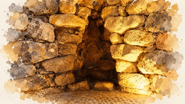
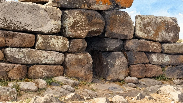
A small niche surrounded by enormous stones conveys the relationship between interior space and the thickness of the central tower. Artificial lighting in the documented view brings out irregular surfaces that can disappear into shadow.

Today

Check the institution’s current opening, booking arrangements and accessible route. Individual rooms, exhibitions and approaches may have separate conditions.

History

The central keep originally contained three superimposed chambers. Corbelled construction allowed the masonry to narrow above the internal spaces. The uppermost chamber is no longer preserved, and the surviving tower is substantially lower than its estimated original height. Access between levels involved arrangements that changed with the building’s use.

How to read this place

The illustration shows a niche in the ground-floor chamber, not an entrance tunnel or the whole tower interior. Compare the size of the recess with the surrounding blocks. Follow the authorised guided route and do not assume every level described in archaeological literature is accessible today.

What to notice

  • The illustration shows a niche in the ground-floor chamber, not an entrance tunnel or the whole tower interior.
  • Compare the size of the recess with the surrounding blocks.
  • Follow the authorised guided route and do not assume every level described in archaeological literature is accessible today.
Detailed sheets
Watercolour: Su Nuraxi central keep, niche in the ground-floor chamber under modern site lighting
Inside the central towerEditorial watercolour · AI-generated · 2026
03

Evidence and interpretation

The village: houses and shared space

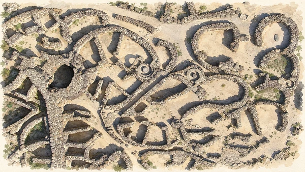
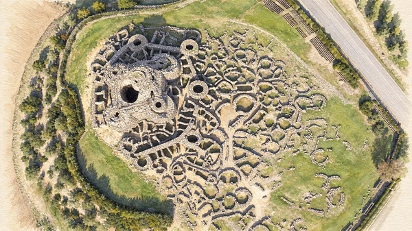
Roofless walls form curved rooms, courts and narrow routes around the tower complex. Their exposed plan helps distinguish domestic organisation from the larger defensive masses, but the remains belong to several periods rather than one frozen moment.

Today

Check the institution’s current opening, booking arrangements and accessible route. Individual rooms, exhibitions and approaches may have separate conditions.

History

The settlement expanded during the later Bronze Age and developed further in the Iron Age. Courtyard houses, paths and water-management arrangements mark changing patterns of habitation. Some buildings have been interpreted as places for communal or ritual activity; these interpretations should be distinguished from the physical features that survive.

How to read this place

Look for thresholds, the relationship of smaller rooms to a court and the paths between building groups. Use the guide’s plan to separate phases. The top-down illustration helps with spatial relationships but cannot supply missing roofs, furniture or a definitive function for every room.

What to notice

  • Look for thresholds, the relationship of smaller rooms to a court and the paths between building groups.
  • Use the guide’s plan to separate phases.
  • The top-down illustration helps with spatial relationships but cannot supply missing roofs, furniture or a definitive function for every room.
Barumini, Su Nuraxi Complex
Watercolour: Su Nuraxi village, overhead detail of roofless circular and courtyard-house foundations
The village: houses and shared spaceEditorial watercolour · AI-generated · 2026
04

Evidence and interpretation

Casa Zapata: a residence becomes a museum

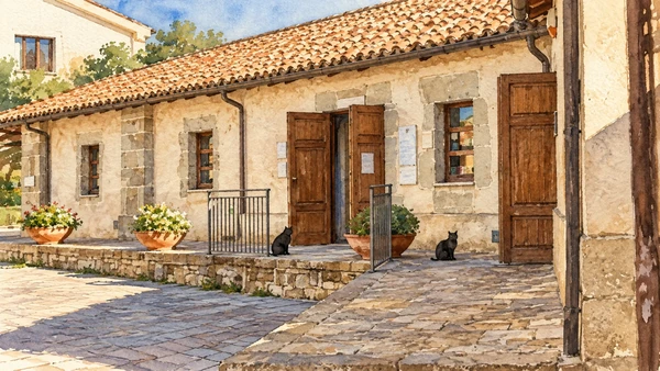
A courtyard and its low tiled wings lead into a complex where archaeology, family archives and rural material culture are presented together. The modest entrance wing in the illustration is one part of a larger early modern residence.

Today

Check the institution’s current opening, booking arrangements and accessible route. Individual rooms, exhibitions and approaches may have separate conditions.

History

The Zapata family held the local fief from the sixteenth century. Their residence was adapted for museum use, revealing the remains of a much earlier nuraghe beneath it. The museum also preserves documents connected with the family and objects associated with agricultural life, including a collection of launeddas.

How to read this place

Read the palace as a later historical layer in its own right. Compare archival evidence with tools and musical instruments rather than treating them as timeless decoration. The courtyard illustration does not show the principal palace facade or the excavation below the exhibition floors.

What to notice

  • Read the palace as a later historical layer in its own right.
  • Compare archival evidence with tools and musical instruments rather than treating them as timeless decoration.
  • The courtyard illustration does not show the principal palace facade or the excavation below the exhibition floors.
Casa Zapata Museum Complex – Fondazione Barumini
Watercolour: Casa Zapata museum complex, courtyard entrance wing with tiled roof and flowerpots
Casa Zapata: a residence becomes a museumEditorial watercolour · AI-generated · 2026
05

Evidence and interpretation

Nuraxi ’e Cresia beneath the palace

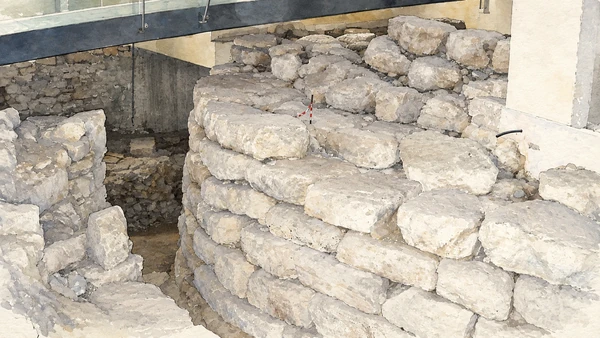
Ancient curved masonry survives below modern walkways and exhibition floors. Here the museum’s structure is deliberately visible: glass, steel and later walls help visitors understand the physical overlap of different periods.

Today

Check the institution’s current opening, booking arrangements and accessible route. Individual rooms, exhibitions and approaches may have separate conditions.

History

Work for the museum uncovered the complex in 1990, followed by further archaeological investigation. Built with local marlstone, it comprises a central tower and three additional towers connected in a trefoil arrangement. Its history differs from that of Su Nuraxi outside the town; the two sites must not be confused.

How to read this place

Observe the excavated wall faces from the permitted museum route. The pale stone in this illustration differs from the darker basalt prominent at Su Nuraxi. Modern columns and glazing belong to the preservation and display of the remains, not to the prehistoric building.

What to notice

  • Observe the excavated wall faces from the permitted museum route.
  • The pale stone in this illustration differs from the darker basalt prominent at Su Nuraxi.
  • Modern columns and glazing belong to the preservation and display of the remains, not to the prehistoric building.
Detailed sheets
Watercolour: Nuraxi ’e Cresia, pale ancient masonry beneath the modern floors of Casa Zapata
Nuraxi ’e Cresia beneath the palaceEditorial watercolour · AI-generated · 2026
06

Evidence and interpretation

Centro Giovanni Lilliu: how ruins are interpreted

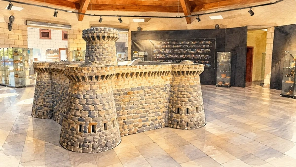
The cultural centre adds a useful pause between looking at archaeological remains and imagining their former appearance. Photographs, models and exhibitions explain the work through which Barumini became widely known.

Today

Check the institution’s current opening, booking arrangements and accessible route. Individual rooms, exhibitions and approaches may have separate conditions.

History

The centre honours Giovanni Lilliu, whose archaeological research was central to the investigation of Su Nuraxi. Its activities connect interpretation of the site with exhibitions and cultural work. A reconstructed model proposes the appearance of a complete nuragic complex, making the distinction between surviving evidence and modern explanation especially clear.

How to read this place

Compare the model with the ruined towers already seen outside. The illustration is explicitly a modern museum model, not a surviving building or a view of Bronze Age life. Consult the foundation for the current exhibition programme; a documented display does not guarantee that every temporary exhibition remains in place.

What to notice

  • Compare the model with the ruined towers already seen outside.
  • The illustration is explicitly a modern museum model, not a surviving building or a view of Bronze Age life.
  • Consult the foundation for the current exhibition programme; a documented display does not guarantee that every temporary exhibition remains in place.
Centro Giovanni Lilliu – Fondazione Barumini
Watercolour: Centro Giovanni Lilliu, modern reconstruction model displayed inside the museum gallery
Centro Giovanni Lilliu: how ruins are interpretedEditorial watercolour · AI-generated · 2026
07

Worship and memory

San Pietro at Tuili

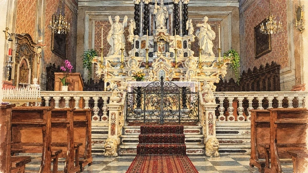
The parish church contains works from different periods within an altered late medieval building. Marble, gilding, painted surfaces and carved wood create a richly layered interior whose objects should be dated separately.

Today

Worship and local religious life continue here. Visitor access may pause for services; consult the church or managing institution before planning an interior visit.

History

The church was consecrated in 1489 and later transformed. The retablo associated with the Maestro di Castelsardo is documented by a payment of 1500. The polychrome marble high altar shown here belongs to the eighteenth-century enrichment of the church and is a different work from that painted altarpiece.

How to read this place

Ask about access to the retablo and take time to distinguish it from the later high altar. The watercolour frames the marble sanctuary, its steps and gate. This is a working parish church, so worship and local opening arrangements shape the visit.

What to notice

  • Ask about access to the retablo and take time to distinguish it from the later high altar.
  • The watercolour frames the marble sanctuary, its steps and gate.
  • This is a working parish church, so worship and local opening arrangements shape the visit.
Chiesa di San Pietro e Retablo di Tuili
Watercolour: San Pietro at Tuili, the Baroque marble high altar; the Renaissance retablo is not pictured
San Pietro at TuiliEditorial watercolour · AI-generated · 2026
08

Terrain and access

The Giara: seasonal water and free-ranging horses

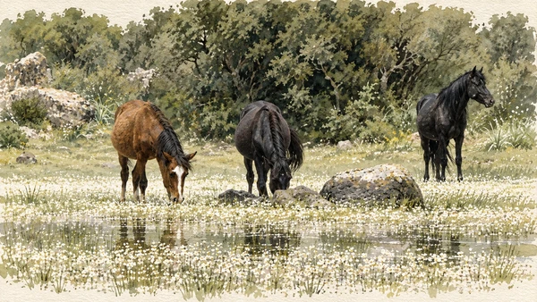
The basalt plateau changes the scale of the journey. Woodland, scrub and shallow seasonal pools form a landscape above the cultivated hills. Small free-ranging horses are part of this environment, rather than an attraction that can be summoned at a viewpoint.

Today

Conditions depend on the exact route and the day. Check the responsible operator, weather and local access notices; use the designated routes and confirm the return journey.

History

Ancient lava flows protected the plateau while surrounding softer ground eroded. Human occupation is recorded by archaeological remains and routes around its edges. The pools, locally known as pauli, respond to seasonal rainfall and are important to the plateau’s ecological life.

How to read this place

Choose a recognised access point and a route suitable for current ground and weather conditions. The springlike wetland scene in the illustration is seasonal, not a promise of water or flowers in every month. Observe horses at a distance and leave plants, rocks and archaeological remains untouched.

What to notice

  • Choose a recognised access point and a route suitable for current ground and weather conditions.
  • The springlike wetland scene in the illustration is seasonal, not a promise of water or flowers in every month.
  • Observe horses at a distance and leave plants, rocks and archaeological remains untouched.
Sa Jara Manna – Giara di Gesturi | SardegnaTurismo – Sito ufficiale del turismo della Regione Sardegna
Watercolour: Giara plateau, three free-ranging horses beside a seasonally wet and flowering pool
The Giara: seasonal water and free-ranging horsesEditorial watercolour · AI-generated · 2026
09

The inhabited landscape

Las Plassas and the castle hill

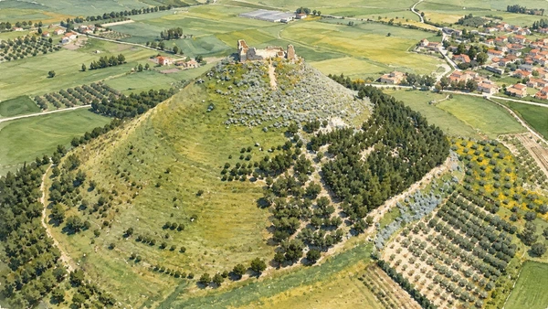
A conical hill rises from a pattern of fields and olive groves, with small surviving castle walls on its summit. The surrounding landscape explains the strategic value of the height more clearly than an isolated close-up of masonry.

Today

This remains an inhabited place. Use pedestrian routes, keep entrances clear and check municipal mobility notices for any restricted area.

History

The medieval Castello di Marmilla belonged to the defensive world of the Giudicato of Arborea and was involved in the conflicts with the Crown of Aragon. Later uses and decay left the fragmentary structure visible today. The local museum offers another way to approach the area’s medieval history.

How to read this place

Begin by viewing the hill from the village and the surrounding public approaches. For any ascent, check the current path and access conditions locally; visible ruins do not imply a maintained or unrestricted interior route. The aerial illustration shows the present remains, not a restored fortress.

What to notice

  • Begin by viewing the hill from the village and the surrounding public approaches.
  • For any ascent, check the current path and access conditions locally; visible ruins do not imply a maintained or unrestricted interior route.
  • The aerial illustration shows the present remains, not a restored fortress.
Las Plassas | SardegnaTurismo – Sito ufficiale del turismo della Regione Sardegna
Watercolour: Las Plassas, the conical castle hill with surviving summit walls above fields and olive groves
Las Plassas and the castle hillEditorial watercolour · AI-generated · 2026
10

Evidence and interpretation

Sa Domu ’e s’Orku at Siddi

Large basalt blocks surround a surprisingly small opening at this Nuragic funerary monument on the plateau near Siddi. The close view makes the scale of the masonry clear without pretending to show the whole structure.

Today

Check the institution’s current opening, booking arrangements and accessible route. Individual rooms, exhibitions and approaches may have separate conditions.

History

The monument belongs to the Bronze Age tradition commonly called tombs of the giants. The name is a later popular expression: these were collective burial places, not evidence of giant inhabitants. Regional heritage information dates Sa Domu ’e s’Orku broadly to 1500–1300 BC.

How to read this place

Read the entrance as one part of a larger funerary arrangement and use the local interpretation to understand the plan. Do not climb on the blocks or assume that entering the chamber is permitted. Siddi lies on a separate outing from Barumini; confirm the route through the local museum and territory information.

What to notice

  • Read the entrance as one part of a larger funerary arrangement and use the local interpretation to understand the plan.
  • Do not climb on the blocks or assume that entering the chamber is permitted.
  • Siddi lies on a separate outing from Barumini; confirm the route through the local museum and territory information.
Siddi | SardegnaTurismo – Sito ufficiale del turismo della Regione Sardegna
Watercolour: Sa Domu ’e s’Orku at Siddi, close study of the small entrance and massive basalt blocks
Sa Domu ’e s’Orku at SiddiEditorial watercolour · AI-generated · 2026

The territory through time

A short chronology

A concise chronology linking the documented sites to the wider story.

  1. Su Nuraxi develops around its central tower.

  2. The surrounding settlement expands.

  3. Courtyard houses and shared routes reshape the village.

  4. The castle of Marmilla controls its hill above Las Plassas.

  5. San Pietro is consecrated; a payment documents the Tuili retablo.

  6. Giovanni Lilliu directs major excavations at Su Nuraxi.

  7. Museum works uncover Nuraxi ’e Cresia beneath Casa Zapata.

  8. Su Nuraxi enters the UNESCO World Heritage List.

Before your visit

Practical information

01

Plan separate days

Choose a manageable set of visits and allow for transport, booked entries and the return journey.

02

Use the exact place name

Sardinia contains separate cities, hill routes and coastal approaches. Confirm the precise locality and route rather than treating nearby names as one destination.

03

Check the institution

Opening hours, tickets, exhibitions and religious access change. Use the linked managing institution shortly before visiting.

04

Check the actual terrain

Steps, gradients and uneven ground vary between the individual sites. Use current route information, weather and closures for the option you choose.

05

Arrange accessible visits

Historic interiors and outdoor approaches can include steps, gradients or uneven surfaces. Ask about the specific route instead of assuming an entire destination is step-free.

06

Respect work and residence

Farms, workshops, churches and historic streets remain in use. Follow signs, keep entrances clear and ask permission before entering private spaces.

Method and sources

Sources and image credits

Prepared on 9 September 2026 from the institutional sources linked below. Historical claims are separated from editorial observations and itinerary suggestions. Older institutional brochures are used for stable cultural context, never as current timetables. Prices, transport schedules, trail status and admission are deliberately left to the responsible operators. Illustrations are not photographs, measured reconstructions or evidence of current conditions.

The eleven images are AI-generated editorial watercolours guided by photographic references. They interpret named places and are not photographs or substitutes for measured plans. Opening hours, tickets, accessible routes, temporary exhibitions and conservation work can change; consult the linked official pages shortly before visiting.

Illustration references and credits