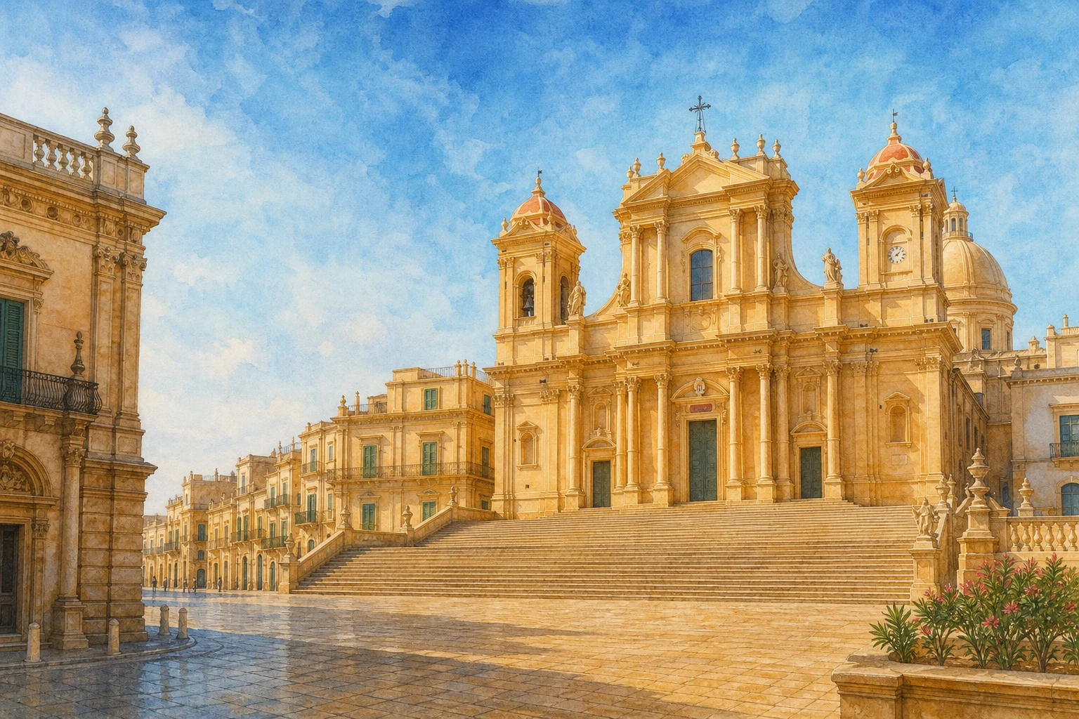
Documentary watercolour of Piazza Municipio in Noto with the Cathedral of San Nicolò, its broad staircase and the warm limestone façades of the Baroque city

Illustrated guide · Sicily

A city rebuilt
as a theatre of light

Ten places through which to read Noto from the destroyed city on Monte Alveria to its new streets, churches, palaces, civic spaces and modern acts of reconstruction.

Explore the places
Noto · earthquake, design, stone and civic life

Reconstruction was an urban argument

Noto is beautiful because rebuilding became a public language.

After the earthquake of 1693, the community did not simply repair the ruined city on Monte Alveria. It moved to another site and organised a new Noto through streets, terraces, squares, staircases, churches, convents and palaces. Stone façades became instruments for placing institutions and families within the city.

The apparent harmony did not arrive in a single drawing or a single decade. Architects, master builders, religious orders, civic officials, aristocratic patrons and craftspeople negotiated construction over generations. Some buildings bend, project or retreat to complete a view; others conserve more sober geometries.

Noto is therefore not a Baroque stage set. It is a city made by loss, hierarchy, experiment, repair and continued habitation.

One destination

Noto,
planned after catastrophe.

The Late Baroque Towns of the Val di Noto form a serial UNESCO property of eight south-eastern Sicilian communities rebuilt after the earthquake of 1693. Noto is distinctive because the old fortified centre was abandoned and the new city was laid out on a different site. The lower slope and the plateau use two grids set at slightly different angles, creating long streets, stepped cross-axes and carefully framed façades.

The celebrated honey-coloured limestone changes with the sun, but colour alone does not explain the city. Corso Vittorio Emanuele carries major religious institutions; Piazza Municipio sets cathedral and town hall in dialogue; Via Nicolaci turns a noble residence and a convent church into a theatrical ascent; the upper streets reveal other palaces, neighbourhoods and the less monumental life required to sustain the whole design.

The selection

Ten places,
one rebuilt city

The route begins where the earlier city ended, enters the new town through its ceremonial eastern edge, follows the principal civic and religious axis, climbs the Nicolaci cross-axis and finishes in the upper streets where noble architecture, neighbourhood topography and later cultural institutions complicate the postcard view.

  1. 01Noto Antica on Monte Alveria
  2. 02Porta Reale and Corso Vittorio Emanuele
  3. 03San Francesco all'Immacolata and the Santissimo Salvatore
  4. 04The Cathedral of San Nicolò
  5. 05Palazzo Ducezio and Piazza Municipio
  6. 06Santa Chiara and the Convent Terrace
  7. 07San Carlo Borromeo and the Jesuit College
  8. 08Via Nicolaci, Palazzo Nicolaci and Montevergini
  9. 09San Domenico, Piazza XVI Maggio and the Theatre
  10. 10Via Cavour and the Upper Town Palaces
01

The city before the city of golden stone

Noto Antica on Monte Alveria

Ruined walls, streets and sacred buildings preserve the place abandoned after the earthquake of 1693.

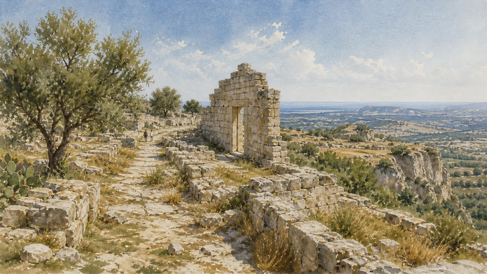
Documentary watercolour of Noto Antica with ruined streets, a surviving stone doorway, olive trees and the Hyblaean landscape from Monte Alveria
THE CITY LEFT ON MONTE ALVERIA

The place today

Noto Antica occupies the defensible summit and slopes of Monte Alveria, several kilometres from the Baroque centre. The Porta della Montagna, sections of fortification, rock-cut passages, the remains of churches and religious houses, urban blocks and the deep valleys around the plateau create an archaeological landscape rather than a single monument. Vegetation and uneven surfaces make the plan less immediate than the straight streets of the new city.

The historical chapter

Ancient Netum developed through indigenous, Greek, Roman, medieval and early modern phases. It was a Roman municipium and later an administrative centre under Islamic and subsequent rulers; the Municipality records its status as capovalle and the title Civitas ingegnosa. The earthquake of 11 January 1693 destroyed the inhabited centre. Choosing a new site turned these ruins into the material origin of Baroque Noto, while objects, cults and family memories moved with the survivors.

What to notice

  • Fortification lines using the steep valleys as part of the city's defence
  • Street and building remains showing a dense town rather than an isolated castle
  • Objects and devotions transferred to the new city, including the cult of San Corrado
Municipality of Noto · Noto Antica
Documentary watercolour of Noto Antica with ruined streets, a surviving stone doorway, olive trees and the Hyblaean landscape from Monte Alveria
THE CITY LEFT ON MONTE ALVERIALow walls, a surviving doorway and the plateau edge keep Noto Antica distinct from the coherent Baroque city built after the earthquake.
02

The ceremonial entrance and the city's long public axis

Porta Reale and Corso Vittorio Emanuele

The eastern gate introduces a street in which façades, squares and staircases were composed as an urban sequence.

Documentary watercolour of Noto Antica with ruined streets, a surviving stone doorway, olive trees and the Hyblaean landscape from Monte Alveria
THE CITY LEFT ON MONTE ALVERIA

The place today

Porta Reale stands at the eastern approach to the historic centre, opening onto Corso Vittorio Emanuele. The present triumphal form belongs to the nineteenth century, but the street beyond expresses the eighteenth-century plan: a broad, gently bending axis connecting San Francesco, Santa Chiara, the cathedral, San Carlo and other institutions. Cross streets rise toward the upper town, so the apparent flat promenade constantly meets changes in level.

The historical chapter

The new site allowed planners to replace the confined medieval form of Noto Antica with two more regular street grids. The Baroque city on the slope used long visual corridors and terraces to organise religious and civic power. Porta Reale was erected for the visit of Ferdinand II in 1838, adding a Bourbon ceremonial threshold to the earlier plan. Its date matters: the gate frames the Baroque city but was not part of the immediate post-earthquake reconstruction.

What to notice

  • The gate's nineteenth-century symbols and masonry compared with eighteenth-century façades
  • Small shifts in the alignment of the Corso that reveal new architectural scenes gradually
  • Stairs and rising cross streets joining the lower monumental axis to the upper town
Italian Ministry of Culture · Late Baroque Noto urban study
03

Religious institutions establish the first great urban terrace

San Francesco all'Immacolata and the Santissimo Salvatore

Church, monastery and seminary turn the eastern Corso into a layered composition of steps, walls and domes.

Documentary watercolour of Noto Antica with ruined streets, a surviving stone doorway, olive trees and the Hyblaean landscape from Monte Alveria
THE CITY LEFT ON MONTE ALVERIA

The place today

A wide stair rises from the Corso to San Francesco all'Immacolata, while the long, high façade of the former Santissimo Salvatore complex shapes the opposite and adjoining street edges. From below, the church, convent buildings, tower and terraces seem coordinated as a single ensemble, yet they served distinct Franciscan, Benedictine, educational and ecclesiastical functions. Upper viewpoints look back toward the gate and countryside.

The historical chapter

The urgent re-establishment of religious communities after 1693 drove much of Noto's early construction. San Francesco was designed in the first half of the eighteenth century by Rosario Gagliardi and Vincenzo Sinatra, combining a more classical façade with Baroque staging. The Benedictine Santissimo Salvatore grew through several campaigns and later uses, including seminary functions. Their scale demonstrates that convents were economic and educational institutions as well as places of worship.

What to notice

  • The staircase acting as architecture between street and church rather than mere access
  • Contrasts between broad planar walls and selected areas of sculptural movement
  • How tower, terraces and long institutional fronts control views at the Corso's eastern end
Italian Ministry of Culture · San Francesco all'Immacolata
04

A long construction history and a modern reconstruction

The Cathedral of San Nicolò

The cathedral's golden façade and broad staircase are inseparable from collapse, engineering and the continuity of civic devotion.

Documentary watercolour of Noto Antica with ruined streets, a surviving stone doorway, olive trees and the Hyblaean landscape from Monte Alveria
THE CITY LEFT ON MONTE ALVERIA

The place today

San Nicolò rises above Piazza Municipio on a monumental staircase, with a two-level façade framed by bell and clock towers and a dome visible behind. Corinthian columns, deep cornices and the central bronze door create strong shadows in the pale limestone. Inside, the three-nave space is markedly lighter and more restrained than many Baroque churches, a result of structural losses and the reconstruction completed in the twenty-first century.

The historical chapter

A provisional church opened soon after the city's relocation, while the larger cathedral developed across the eighteenth century under several designers and master builders; this long process makes a single attribution uncertain. The church became cathedral in 1844. After earlier failures, much of the nave, transept and dome collapsed on 13 March 1996 because of structural defects aggravated by seismic damage. Reconstruction combined traditional materials and forms with modern anti-seismic design, and the church reopened in 2007.

What to notice

  • The three-part façade and free-standing columns producing movement through shadow
  • The visual axis across Piazza Municipio toward Palazzo Ducezio
  • Differences between surviving eighteenth-century fabric and the carefully reconstructed interior
Italian Ministry of Culture · Cathedral of San Nicolò
05

Civic authority placed directly opposite the cathedral

Palazzo Ducezio and Piazza Municipio

The town hall's curved arcade creates a measured dialogue between religious and municipal power.

Documentary watercolour of Noto Antica with ruined streets, a surviving stone doorway, olive trees and the Hyblaean landscape from Monte Alveria
THE CITY LEFT ON MONTE ALVERIA

The place today

Palazzo Ducezio occupies the lower side of Piazza Municipio, facing the cathedral. Twenty Ionic-columned arches form the long ground-floor loggia, while a convex central section advances toward the square. A second storey, added in the twentieth century from an earlier design, changes the silhouette visible in historic photographs. Inside, the oval Sala degli Specchi preserves a later ceremonial interior with mirrors, gilding and painted decoration.

The historical chapter

Construction began in 1742 under Vincenzo Sinatra and continued to about 1760–61. A plan reportedly acquired in Montpellier introduced references to French palace architecture, adapted to the civic setting through concave and convex movement. The semicircular entrance stair followed in 1840 after street levels changed. Naming the building for Ducezio, the Sicel leader associated with ancient Neas, connected the new municipal government to a deliberately deep local past.

What to notice

  • The central convex bay and receding lateral lines across the long arcade
  • The precise face-to-face placement of town hall and cathedral
  • The upper floor as a later alteration visible by comparing archival images
Italian Ministry of Culture · Palazzo Ducezio
06

An enclosed community overlooking the new public city

Santa Chiara and the Convent Terrace

The former Poor Clares' complex reveals how convent architecture negotiated enclosure, worship and views over the Corso.

Documentary watercolour of Noto Antica with ruined streets, a surviving stone doorway, olive trees and the Hyblaean landscape from Monte Alveria
THE CITY LEFT ON MONTE ALVERIA

The place today

Santa Chiara stands close to the cathedral but presents a more contained exterior to the Corso. Inside, a centrally organised oval space, white stuccoes, columns and galleries create a vertical interior. The former convent's accessible terraces and windows offer oblique views across roofs, the cathedral and the Salvatore complex, making the topography of the lower city especially legible.

The historical chapter

The Poor Clares established their new complex soon after the move from Noto Antica. Work is associated with Rosario Gagliardi and developed during the first half of the eighteenth century. Enclosure shaped circulation and the position of galleries from which nuns could participate without entering public space. Later suppression of religious orders changed ownership and use, while restoration made parts of the complex accessible as cultural spaces.

What to notice

  • The oval interior and layered galleries rather than a conventional long nave
  • Openings designed around the requirements of monastic enclosure
  • From the terrace, the slight differences in street grids and building levels
Italian Ministry of Culture · Ex-conventual churches of Noto
07

A vertical façade inside the long horizontal Corso

San Carlo Borromeo and the Jesuit College

Free columns, changing orders and a bell-tower viewpoint compress Baroque movement into a narrow street frontage.

Documentary watercolour of Noto Antica with ruined streets, a surviving stone doorway, olive trees and the Hyblaean landscape from Monte Alveria
THE CITY LEFT ON MONTE ALVERIA

The place today

San Carlo al Corso presents a tall three-order façade slightly set back from the principal street. Doric, Ionic and Corinthian columns rise in sequence, while niches, mouldings and projecting cornices intensify the narrow frontage. The adjoining former Jesuit college extends the institutional presence along the block. When accessible, the bell-tower terrace provides a close urban view rather than a distant panorama.

The historical chapter

The church formed part of the Jesuit reconstruction of religious and educational life in the new city and is closely associated with Rosario Gagliardi's architectural language. Its alternating concave and convex elements and free columns relate it to San Domenico without simply repeating that church. During the long closure and reconstruction of the cathedral after 1996, San Carlo served as vice-cathedral and housed the silver reliquary of San Corrado, adding a modern civic chapter to the Baroque building.

What to notice

  • The change of column order from one level to the next
  • Curved and projecting surfaces designed for a confined street view
  • The relationship between church façade and the longer educational block
Italian Ministry of Culture · Church of San Carlo Borromeo
Documentary watercolour of Via Nicolaci in Noto with Palazzo Nicolaci's carved Baroque balconies, Montevergini and flower-petal pavement designs
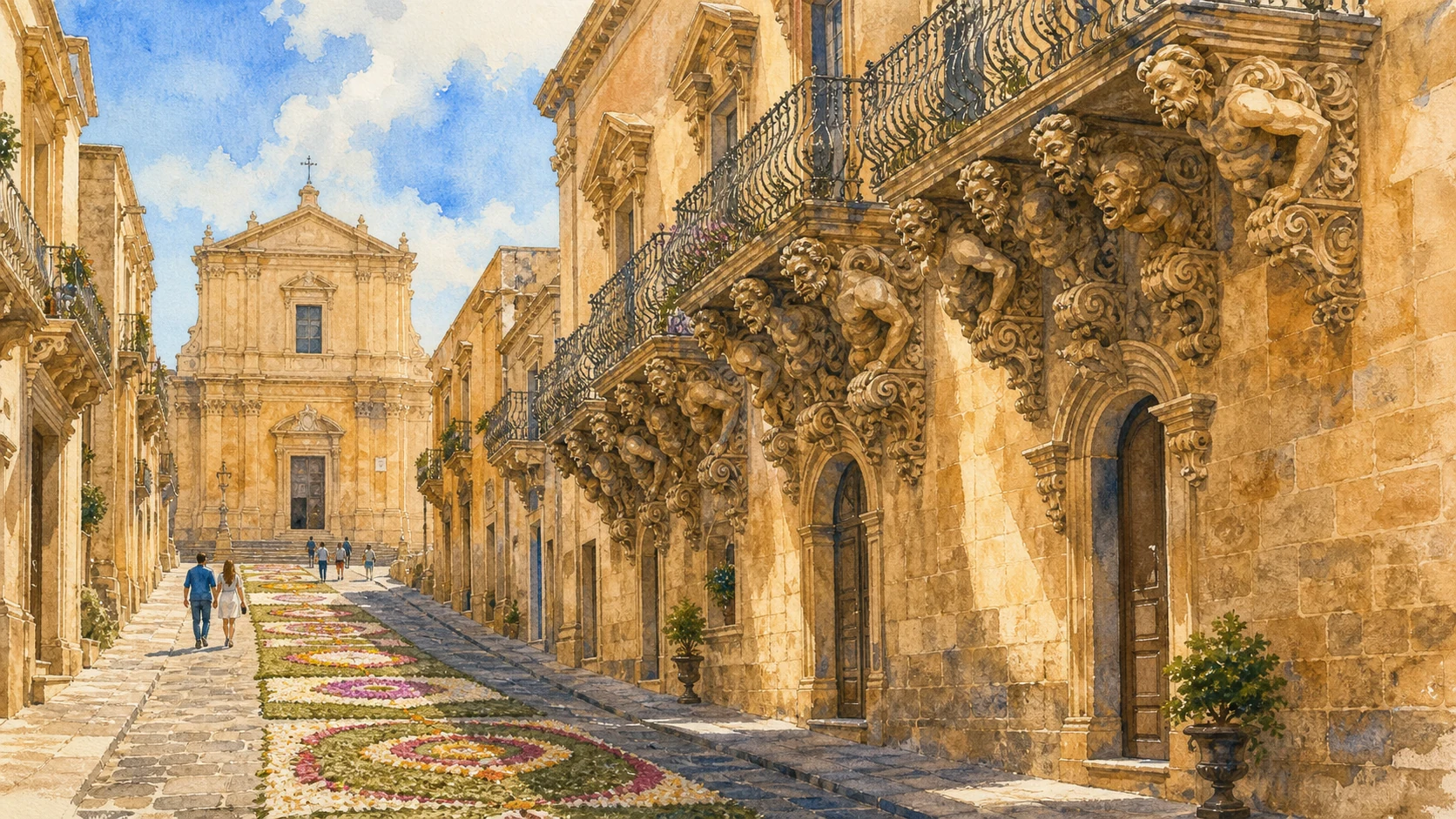
BAROQUE BALCONIES ABOVE A STREET OF FLOWERSPalazzo Nicolaci's carved corbels, the rising perspective toward Montevergini and a restrained Infiorata pattern make the street a living stage.
08

A noble street framed by balconies and a concave church

Via Nicolaci, Palazzo Nicolaci and Montevergini

One rising cross-axis joins aristocratic self-display, monastic architecture and Noto's living festival culture.

Documentary watercolour of Via Nicolaci in Noto with Palazzo Nicolaci's carved Baroque balconies, Montevergini and flower-petal pavement designs
BAROQUE BALCONIES ABOVE A STREET OF FLOWERS

The place today

Via Corrado Nicolaci climbs from the Corso beside the palace's famous balconies toward the twin-towered concave façade of Montevergini. Palazzo Nicolaci contains a courtyard and around ninety rooms across four levels; the restored piano nobile preserves decorated salons, while part of the building houses the municipal library. Stone corbels beneath the balconies take the form of lions, sphinxes, sirens, hippogriffs, winged horses, angels and grotesque faces.

The historical chapter

Work on the Nicolaci residence began around 1720 and continued to 1765 with the participation of Rosario Gagliardi, Vincenzo Sinatra and local craftsmen. The architectural display represents the wealth and erudition of a leading family, while the library records later civic reuse. At the top of the street, Sinatra's Montevergini façade combines Roman Baroque curvature, French references and increasing neoclassical restraint. The annual Infiorata now overlays the ascent with temporary floral design.

What to notice

  • Each balcony corbel as a different sculptural invention supporting the ironwork above
  • The palace's low-angle street view terminating at Montevergini
  • Permanent architecture and temporary flower compositions kept conceptually distinct
Italian Ministry of Culture · Palazzo Nicolaci
09

Baroque religious architecture meets the nineteenth-century civic stage

San Domenico, Piazza XVI Maggio and the Theatre

The square places Gagliardi's masterwork opposite a later theatre, showing cultural life continuing beyond reconstruction.

Documentary watercolour of Via Nicolaci in Noto with Palazzo Nicolaci's carved Baroque balconies, Montevergini and flower-petal pavement designs
BAROQUE BALCONIES ABOVE A STREET OF FLOWERS

The place today

San Domenico turns its strongly curved façade toward Piazza XVI Maggio and the garden of Villetta Ercole. Free columns, niches and layered planes change with every step around the square. Across the open space, the compact Teatro Tina Di Lorenzo presents a nineteenth-century civic façade; inside are four tiers of boxes and a gallery. The ensemble is visually coherent but historically composed of different centuries.

The historical chapter

Rosario Gagliardi built San Domenico between 1703 and 1727 for the Dominican order. Its former convent later served educational and library functions. The desire for a purpose-built civic theatre emerged much later: design began in 1851, construction passed from Francesco Sortino to Francesco Cassone, and the theatre opened in 1870. Together the buildings show how the planned city acquired new secular institutions without abandoning its Baroque public spaces.

What to notice

  • San Domenico's convex central body and concave transitions between columned bays
  • How the garden keeps enough distance for the façade to be read obliquely
  • The theatre's later scale and decoration rather than treating the square as purely Baroque
Italian Ministry of Culture · San Domenico
10

Beyond the Corso, a second reading of class and urban form

Via Cavour and the Upper Town Palaces

Palazzo Trigona, Castelluccio and other residences reveal Baroque invention, neoclassical restraint and the city's vertical social geography.

Documentary watercolour of Via Nicolaci in Noto with Palazzo Nicolaci's carved Baroque balconies, Montevergini and flower-petal pavement designs
BAROQUE BALCONIES ABOVE A STREET OF FLOWERS

The place today

Via Cavour runs through the upper historic centre behind the cathedral zone. Palazzo Trigona presents an extensive late-Baroque front; Palazzo Castelluccio, Palazzo Impellizzeri and other residences use more regular classical or neoclassical vocabularies. Smaller streets, stairs, churches and houses extend beyond the major façades. This higher grid feels less like a continuous ceremonial corridor and more like a lived network of neighbourhood blocks.

The historical chapter

The new city's plan distributed institutions and social groups through both slope and plateau. Noble families commissioned residences as expressions of lineage, wealth and changing taste, but not all selected the same ornamental language. The Ministry of Culture distinguishes highly plastic late-Baroque façades such as Nicolaci and Trigona from more sober, geometrically ordered buildings including Castelluccio and Impellizzeri. Reading those differences prevents 'Noto Baroque' from becoming one uniform style.

What to notice

  • Contrasts between sculptural balcony supports and flatter neoclassical window frames
  • The upper grid's quieter blocks behind the monumental Corso
  • Ordinary houses and service streets that made palace and convent life possible
Italian Ministry of Culture · Noble palaces of Noto

The city through time

Ten dates for orientation

A chronology connecting ancient Netum, medieval administration, the earthquake, the long Baroque construction campaign, later civic architecture, collapse, reconstruction and World Heritage recognition.

  1. Netum holds the status of municipium; the long-lived settlement on Monte Alveria continues through later political and religious transformations.

  2. Noto becomes an important administrative, military and cultural centre of south-eastern Sicily, later remembered as a capovalle and fortified city.

  3. A catastrophic earthquake destroys the old city and many communities across south-eastern Sicily, causing immense human loss.

  4. Survivors establish Noto on the Meti site; two related street grids organise the slope, plateau, institutional axes and residential quarters.

  5. Rosario Gagliardi constructs San Domenico, one of the clearest early masterworks of Noto's new architectural language.

  6. Palazzo Nicolaci develops across several campaigns, joining aristocratic residence, urban theatre and later municipal cultural use.

  7. Palazzo Ducezio takes form opposite the cathedral, establishing the civic half of Piazza Municipio's symbolic dialogue.

  8. The cathedral's nave, transept and dome collapse after structural weakness and earlier seismic damage; a major reconstruction follows.

  9. UNESCO inscribes the Late Baroque Towns of the Val di Noto, including the entire historic centre of Noto, under criteria i, ii, iv and v.

  10. The Cathedral of San Nicolò reopens after reconstruction that combines traditional form and material with modern structural safeguards.

Before your visit

Practical information,
without turning it into promises

01

Separate old and new

Noto Antica is outside the Baroque centre and needs its own travel time, footwear and archaeological attention. It should not be added as a quick stop inside the Corso walk.

02

Walk at two levels

The Corso is only the lower monumental axis. Use Via Nicolaci, stair streets and Via Cavour to understand the two grids, upper neighbourhoods and changes in social architecture.

03

Check interiors

Churches, palace rooms, towers, terraces and the theatre have independent hours, worship schedules and accessibility conditions. A façade being visible does not mean the interior is open.

04

Read restoration honestly

Noto is an active seismic landscape. Reconstructed fabric, structural repair and recent art inside the cathedral are part of the city's history, not details to hide behind an untouched-Baroque myth.

Sources

The guide uses UNESCO for the eight-town property's scope and the distinction between Noto's relocation and other reconstruction strategies; the Municipality for Noto Antica, the cathedral and the civic theatre; and the Italian Ministry of Culture's ICCD catalogue and regional heritage study for urban planning, churches, convents, Palazzo Ducezio, Palazzo Nicolaci and the noble residences. Uncertain attributions are presented as such, and nineteenth- and twentieth-century additions are not labelled Baroque merely because they occupy the same views.

The hero image is an illustration, not a photograph or architectural reconstruction. Churches remain places of worship; palace interiors, towers, terraces, Noto Antica paths, exhibitions and theatre access can change. Check the linked institutions shortly before visiting and respect closures, services and restoration work.