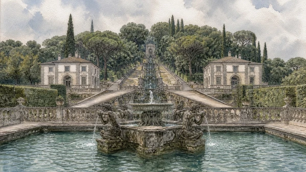
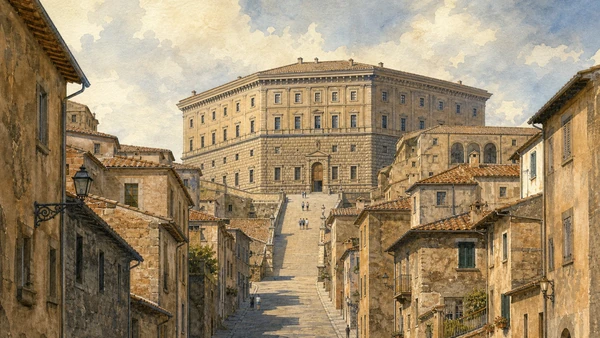
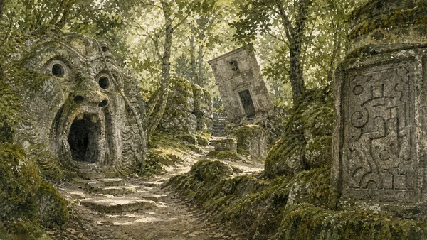
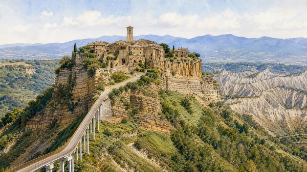
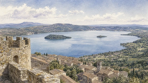
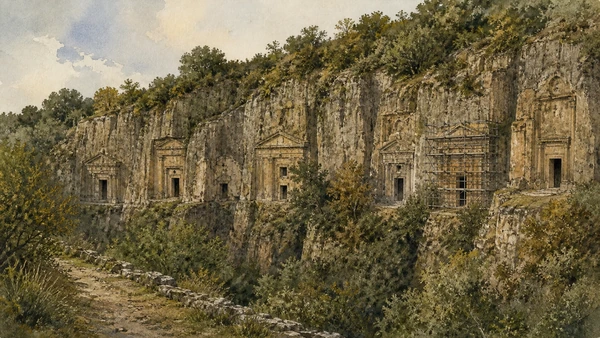
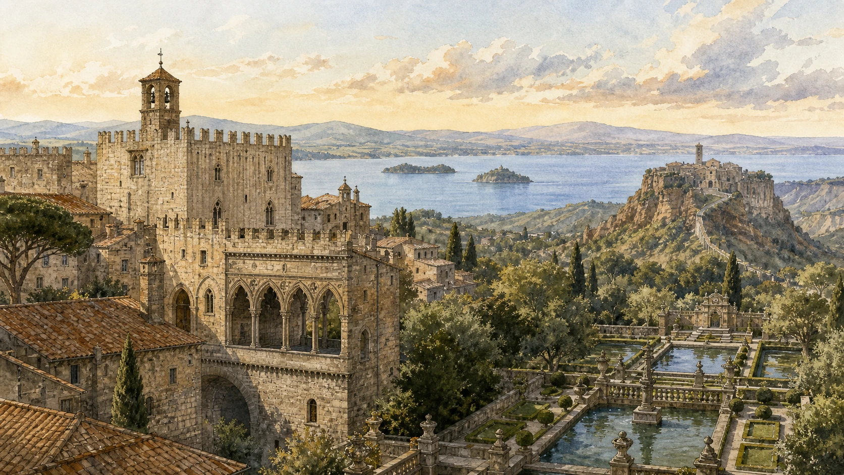
Original documentary watercolour panorama joining Viterbo's papal skyline, Villa Lante water gardens, Lake Bolsena and the tufa cliffs of Civita di Bagnoregio

Lazio Guide 05 · Papal city, volcanic lakes and carved tufa

Viterbo
& Tuscia

A documented route through medieval quarters, papal chambers, water gardens, volcanic ground, fragile hill towns and Etruscan rock landscapes.

Plan the route
Viterbo · Cimini · Bolsena · tufa country10 chapters · three to four days

Why this territory matters

Tuscia is not one preserved medieval world: it is a layered territory built from papal power, volcanic ground, engineered water and repeated abandonment.

Tuscia is a useful modern travel name, not a precise historical province with permanent borders. Around Viterbo it gathers places connected by Etruscan memory, medieval government, papal patronage and a volcanic landscape of crater lakes, peperino, tufa and thermal springs. The connections are real, but they do not make every town part of one continuous story. Viterbo, Caprarola, Bagnaia, Bomarzo, Bagnoregio, Bolsena and Norchia each require their own chronology.

Viterbo became a papal city in the thirteenth century; nearby villas later transformed water, gardens and long ceremonial approaches into instruments of Renaissance power. Beyond them, the earth sets the terms. Civita stands above eroding clay and volcanic rock. Lake Bolsena occupies a volcanic basin. At Norchia, tomb façades were cut directly into tufa cliffs. The picturesque view is therefore never merely scenery: geology controls settlement, access, conservation and the routes a visitor can actually follow.

This guide links those systems without pretending that they fit into a quick excursion from Rome. Public transport radiates unevenly from Viterbo, while rural sites, opening days, weather closures and fragile paths change the practical map. Give the territory three days with a car, or four days when using mixed transport and guided access. The reward is not coverage for its own sake, but the chance to see how different periods repeatedly reused the same water, stone and strategic ground.

Move from palace to street, garden to watercourse, lake rim to tufa edge; the landscape is the archive that holds these separate histories together.

The route

Plan your visit

Keep Viterbo as the base and group the outer sites by direction. The old city needs a full day; Villa Lante and Caprarola form a deliberate garden-and-power circuit; Bomarzo and Civita demand slower, separate readings; Bolsena and the northern tufa country need daylight and flexible transport. Norchia is included as a conservation landscape, not a guaranteed public visit.

Day one

Papal Viterbo on foot

Begin at Piazza San Lorenzo and the Palazzo dei Papi, continue through San Pellegrino and Pianoscarano, then end at the Bullicame landscape only with current access information.

Day two

Water and power

Read Villa Lante in Bagnaia from its descending water chain, then Caprarola from the long urban axis to the pentagonal Farnese palace and seasonal gardens.

Day three

Invention and erosion

Give the Sacro Bosco a focused morning and Civita di Bagnoregio a separate afternoon so that carved peperino and unstable calanchi are not reduced to two picturesque photographs.

Day four or extension

Volcanic lake and tufa frontier

Use Bolsena’s territorial museum and lakeshore to understand the volcanic basin; approach Norchia only through officially announced access or guided conservation initiatives.

Ten chapters

Explore the places

The chapters move from Viterbo’s civic core to villas, water, volcanic terrain and the tufa frontier. Use the index without collapsing distinct towns into one timeless Tuscia.

  1. 01Palazzo dei Papi and Piazza San Lorenzo
  2. 02San Pellegrino and the medieval domestic city
  3. 03Pianoscarano, city walls and the Via Francigena
  4. 04Bullicame: the thermal landscape beyond the spa image
  5. 05Villa Lante at Bagnaia: water as architecture
  6. 06Palazzo Farnese at Caprarola: power on an axis
  7. 07The Sacro Bosco at Bomarzo: cultivated uncertainty
  8. 08Civita di Bagnoregio and the calanchi
  9. 09Lake Bolsena: volcanic basin and territorial museum
  10. 10Norchia: the rock necropolis as a conservation landscape
01

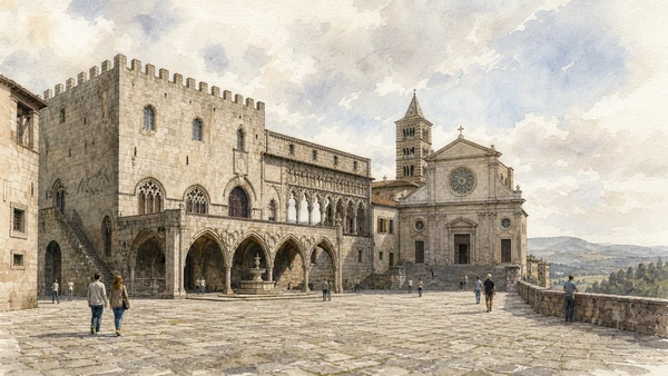
A cathedral square, a fortified residence and an open loggia record the moment when Viterbo became a working centre of papal government

Palazzo dei Papi and Piazza San Lorenzo

The palace is not a detached monument: it belongs to a civic-religious complex shaped by papal residence, election and later museum use.

Today

Piazza San Lorenzo is reached through a compact medieval fabric and opens abruptly onto the cathedral, the former papal palace and the valley edge. The palace visit includes the great hall associated with papal elections, the loggia with its slender arches and fountain, and museum spaces connected with the cathedral complex. Current Comune information combines several ticket options, so the exact route, guided times and included rooms should be checked before arrival rather than inferred from the façade alone.

History

Pope Alexander IV transferred the papal court to Viterbo in 1257. The palace grew from an earlier episcopal building and was enlarged in the 1260s, including the famous loggia of 1267. The papal election held from 1268 to 1271 became the longest in history; civic pressure on the cardinals later entered popular legend, while the experience helped frame the stricter election rules issued by Gregory X at the Second Council of Lyon in 1274.

How to read this place

The hall belongs to a key episode in papal election history, while later regulations established further conclave customs. The election is central, but the formal system developed through subsequent regulation. Read the palace as infrastructure for a mobile medieval court: assembly space, access control, episcopal proximity and a defensive position above the city. The open loggia now appears delicate, yet its location made authority visible across both square and landscape.

What to notice

  • Difference between the heavy palace mass and the perforated loggia
  • Cathedral, bishop’s buildings and palace forming one institutional group
  • Valley edge turning the square into a controlled civic stage
Comune di Viterbo · Palazzo dei Papi
Original documentary watercolour of Piazza San Lorenzo with Viterbo Cathedral, the fortified Palazzo dei Papi and its open Gothic loggia
Palazzo dei Papi and Piazza San LorenzoOriginal Merlintravel documentary watercolour · 2026
02

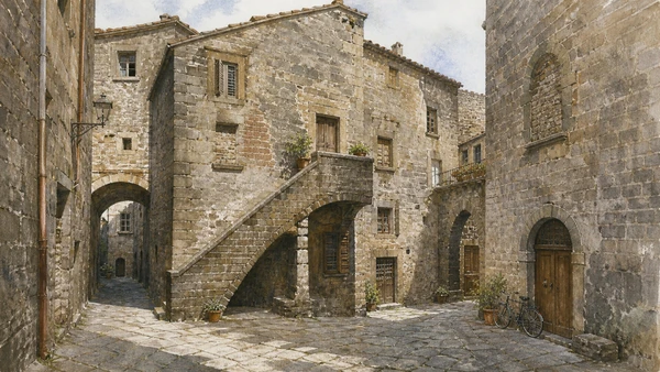
Stone bridges, exterior stairs and tower houses preserve a street system whose character comes from ordinary building types as much as famous palaces

San Pellegrino and the medieval domestic city

Viterbo’s best-known quarter is strongest when read as an inhabited urban fabric, not as a decorative backdrop emptied of later life.

Today

Via San Pellegrino leads through narrow passages, arches, small squares and houses built in dark local stone. The characteristic profferlo combines an exterior stair with an arch sheltering the entrance or work space below. Piazza San Pellegrino gathers the church and the Alessandri palace, but the district extends into a network of lesser buildings, reused ground floors and uneven paving. Events and floral displays can transform the streets temporarily; the permanent evidence lies in thresholds, wall joins and changing floor levels.

History

The quarter developed strongly between the eleventh and thirteenth centuries inside Viterbo’s expanding walls. Merchant and artisan households combined residence, storage and work. Tower houses and fortified palaces expressed competition among elite families, while more modest structures were repeatedly joined or subdivided. Later plaster removal and restoration helped produce the unified stone image now associated with the district, so apparent medieval consistency also has a modern conservation history.

How to read this place

Do not use ‘untouched’ or imagine that every exposed wall surface belongs to one century. A living quarter accumulates replacement windows, blocked openings, raised streets and reused masonry. The profferlo is a useful type rather than a universal house plan. Move slowly enough to distinguish structural evidence from the picturesque effects produced by flowers, signs and curated lighting.

What to notice

  • Profferli connecting street, stair and sheltered ground-floor doorway
  • Wall seams revealing houses enlarged or combined over time
  • Small squares interrupting the apparent continuity of narrow lanes
Comune di Viterbo · San Pellegrino
Original documentary watercolour of San Pellegrino's narrow stone street with profferlo stairs, arches and inhabited medieval houses
San Pellegrino and the medieval domestic cityOriginal Merlintravel documentary watercolour · 2026
03

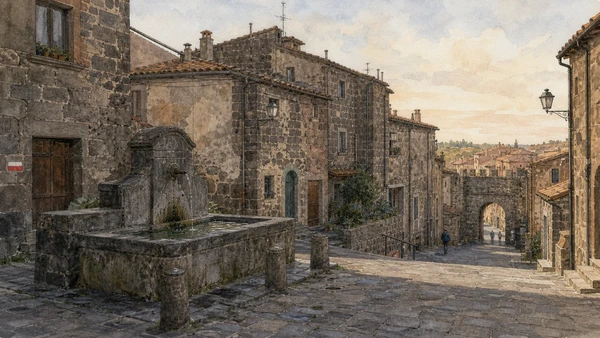
Fountains, gates and working streets reconnect monumental Viterbo with movement, water supply and the long-distance road toward Rome

Pianoscarano, city walls and the Via Francigena

The southern quarter shows how pilgrims, animals, water and daily trade passed through a city usually represented by palaces alone.

Today

Pianoscarano occupies the lower southern part of the historic centre around the fountain of Piazza Fontan di Piano. Medieval houses, workshops and steep connections approach the walls and Porta del Carmine. The modern Via Francigena route passes through Viterbo as part of a signed walking network, but urban traffic, accommodation and route variants still require current planning. The quarter is a place to notice gradients and infrastructure rather than chase a single headline monument.

History

Viterbo’s walls expanded as separate settlements and fortified nuclei were joined. Pianoscarano developed beside routes, water points and productive activity. The fountain, traditionally dated to the thirteenth century and repeatedly restored, made communal supply visible in a neighbourhood associated with artisans and livestock. Pilgrims travelling between the north and Rome used a changing network of roads; the modern Francigena itinerary formalises one heritage route through that much longer history of movement.

How to read this place

A present trail sign is not proof that every medieval traveller followed exactly the same line. Nor is the quarter a frozen popular counterweight to elite San Lorenzo. Read the fountain as managed infrastructure, the walls as structures repeatedly repaired, and the Francigena as both historical corridor and contemporary cultural project. The ordinary city is where those layers remain easiest to test against one another.

What to notice

  • Street gradients linking lower water points to gates and upper civic centres
  • Masonry repairs distinguishing long wall history from one building campaign
  • Modern waymarks translating a broad historical corridor into a usable route
Comune di Viterbo · Via Francigena programme
Original documentary watercolour of Pianoscarano's stone fountain, descending streets, city gate and discreet Via Francigena waymark
Pianoscarano, city walls and the Via FrancigenaOriginal Merlintravel documentary watercolour · 2026
04

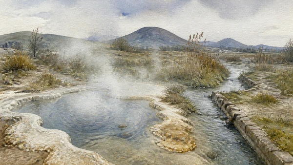
Hot water, mineral deposits and literary memory occupy a changing urban edge whose future is still being designed

Bullicame: the thermal landscape beyond the spa image

The spring is geologically and culturally important, but present access and bathing conditions must never be assumed from old travel accounts.

Today

The Bullicame lies west of Viterbo within a thermal landscape of springs, channels, open ground and modern infrastructure. Its hot sulphurous water and pale mineral deposits remain visually distinctive. The Comune approved a masterplan for a larger thermal park in December 2025, explicitly framing regeneration as a continuing project. That status matters: visitors should consult current municipal information for access, safety and any permitted use rather than treating online photographs of informal bathing as an invitation.

History

Thermal waters around Viterbo have been used across ancient, medieval and modern periods. Dante placed the Bullicame in Inferno XIV as a familiar image for a hot stream whose channels recalled waters distributed among local women. The passage is literary evidence of the spring’s medieval fame, not a technical description of today’s site. Later bathhouses, land use and hydraulic works altered the setting and the paths by which water reached different users.

How to read this place

Do not reduce the Bullicame to a free natural pool. Temperature, water quality, ownership, maintenance and authorised access are contemporary questions. The landscape is valuable even without bathing: read the meeting of geology and channelled water, then compare Dante’s compressed image with the evolving municipal park proposal. Future renderings should be identified as plans, not confused with completed works.

What to notice

  • White mineral crust marking the path and cooling of thermal water
  • Natural spring and human-made channels forming one hydraulic landscape
  • Difference between existing ground and proposed park interventions
Comune di Viterbo · Bullicame thermal park masterplan
Original documentary watercolour of the Bullicame spring landscape with steaming water, pale mineral deposits and modest channels outside Viterbo
Bullicame: the thermal landscape beyond the spa imageOriginal Merlintravel documentary watercolour · 2026
05

Water descends while the visitor climbs, turning gravity, woodland and paired casino buildings into a controlled sequence

Villa Lante at Bagnaia: water as architecture

The garden is not organised around one dominant palace; its fountains, terraces and two matching buildings make movement the central design.

Today

Villa Lante is entered from Bagnaia and rises through formal parterres toward a shaded upper wood. The square Fountain of the Moors anchors the lower garden between two near-matching casino buildings. Above it, ramps, a long stone water chain, sculpted fountains and a table with a water channel structure the ascent. Paths and hydraulic surfaces can be affected by restoration, weather and seasonal management; official 2026 notices also list a shortened Tuesday schedule and possible closures in adverse conditions.

History

The garden took shape mainly in the later sixteenth century under Cardinal Gianfrancesco Gambara, with designs traditionally associated with Jacopo Barozzi da Vignola and later additions under Cardinal Alessandro Peretti Montalto. The two casino buildings were completed in different patronal phases. Water drawn from the Cimini slopes descends through an engineered system that joins practical supply, sensory effect and symbolic order.

How to read this place

Do not force the garden into a single author or date. Its apparent symmetry masks successive patrons and modifications. The water chain is not decoration applied to a palace forecourt; it is the spatial spine that reverses the visitor’s upward movement. Compare the controlled geometry below with the darker woodland above, where designed transitions depend on maintenance as much as original intention.

What to notice

  • Water moving downhill against the visitor’s upward route
  • Two casino buildings balancing the garden without one central block
  • Shift from geometric parterre to shaded bosco and spring architecture
Ministero della Cultura · Villa Lante
Original documentary watercolour looking up Villa Lante's terraces from the Fountain of the Moors toward the water chain and wooded slope
Villa Lante at Bagnaia: water as architectureOriginal Merlintravel documentary watercolour · 2026
06

A pentagonal fortress became a ceremonial villa whose long approach reorganised both interior movement and the town below

Palazzo Farnese at Caprarola: power on an axis

The building’s celebrated geometry matters because it controls approach, courtyard, painted rooms and the territorial view together.

Today

Caprarola’s main street rises toward an immense trapezoidal forecourt and the pentagonal palace above it. Inside, a circular courtyard, the spiral Scala Regia and frescoed state rooms lead through a carefully ranked sequence. Gardens and the upper casino extend the route behind the palace, but their hours are shorter than the interior and the park closes in adverse weather. Current MiC information lists Monday closure, while group and seasonal conditions should be checked directly.

History

Cardinal Alessandro Farnese the Elder commissioned a fortified pentagonal structure in the early sixteenth century. From 1559, his grandson Cardinal Alessandro Farnese transformed the unfinished fortress with Jacopo Barozzi da Vignola into a villa-palace completed largely by 1575. Fresco cycles by several artists connected family, Church, geography and classical culture. The town’s approach was reshaped to make arrival itself part of the political image.

How to read this place

The pentagon is not a visual trick isolated from use. Corner bastions, circular court and ceremonial stair mediate between an inherited fortress plan and a residential programme. Frescoed maps and narratives express sixteenth-century knowledge and Farnese ambition; they are not neutral records. Stand on the urban axis before entering, because the palace’s territorial claim begins well below its door.

What to notice

  • Town street, forecourt and palace entrance aligned as one ascent
  • Circular courtyard inscribed within the inherited pentagonal mass
  • Scala Regia allowing ceremonial movement through a continuous spiral
Ministero della Cultura · Palazzo Farnese, Caprarola
Original documentary watercolour from Caprarola's rising urban axis toward the pentagonal Palazzo Farnese and its ceremonial forecourt
Palazzo Farnese at Caprarola: power on an axisOriginal Merlintravel documentary watercolour · 2026
07

Figures cut from local peperino interrupt a wooded slope in a programme that resists one secure narrative

The Sacro Bosco at Bomarzo: cultivated uncertainty

The park is most convincing when its monsters, inscriptions and tilted architecture are allowed to remain enigmatic rather than decoded as one allegory.

Today

The privately managed Sacro Bosco occupies a wooded, uneven slope below Bomarzo. Monumental heads, animals, mythic figures, fountains, inscriptions and an intentionally leaning house appear in a route whose vegetation is part of the experience. Stone can be wet and paths irregular. Official opening and ticket information belongs to the park itself; its modern maintenance and visitor circulation shape how the sixteenth-century works are encountered.

History

The complex was created in the later sixteenth century for Pier Francesco Orsini, known as Vicino. Sculptures and structures were worked largely from local volcanic peperino and distributed through the natural terrain. Later neglect allowed vegetation to absorb the ensemble before twentieth-century attention and restoration made it an international reference. Individual attributions and the precise sequence of original meanings remain debated.

How to read this place

Avoid presenting the park as a simple memorial to Orsini’s wife or a complete code that one modern theory has solved. Its inscriptions sometimes contradict expectations and its figures change scale and viewpoint. The famous open mouth is one episode, not the whole park. Compare carved boulder, built architecture and living woodland to see how uncertainty was designed into movement.

What to notice

  • Figures emerging from boulders rather than placed as detached statues
  • Inscriptions guiding and destabilising interpretation at the same time
  • The leaning house using bodily imbalance as part of the route
Sacro Bosco di Bomarzo · official history
Original documentary watercolour of Bomarzo's wooded slope with peperino sculptures, an enigmatic inscription and the leaning house
The Sacro Bosco at Bomarzo: cultivated uncertaintyOriginal Merlintravel documentary watercolour · 2026
08

A pedestrian bridge crosses living geological instability, joining a shrinking tufa crown to the larger town of Bagnoregio

Civita di Bagnoregio and the calanchi

The famous view is a record of erosion, engineering and managed visitation, not the image of a timeless isolated village.

Today

Civita is approached on foot across a long modern bridge from the Bagnoregio side. The settlement occupies a narrow volcanic-tufa platform above deeply eroded clay valleys and calanchi. Ticketing and local services are coordinated through Casa Civita and municipal arrangements that can change. The bridge is exposed to sun and wind, while steep gradients and limited resident access make crowd management and mobility central practical issues.

History

The hill belongs to a landscape in which resistant volcanic deposits rest above softer marine clays. Water, slope failure and earthquakes progressively narrowed the ridge and removed former access routes and buildings. The inhabited nucleus preserves medieval and later fabric, but repeated repair, depopulation and tourism have transformed its use. The modern bridge solves one access problem while making the separation from Bagnoregio visually dramatic.

How to read this place

The phrase ‘dying town’ is a powerful tourism label, not a geological diagnosis or complete social history. Civita is neither abandoned nor stable. Read retaining works, repaired edges and the bridge alongside church, square and houses. The surrounding calanchi are not empty scenery: they show active processes that continue to determine conservation and everyday logistics.

What to notice

  • Hard volcanic cap resting above softer, visibly eroded clay
  • Modern pedestrian bridge replacing earlier and less stable connections
  • Retaining structures and repaired edges revealing continual maintenance
Regione Lazio · Civita di Bagnoregio geological documentation
Original documentary watercolour of Civita di Bagnoregio on its tufa crown, the pedestrian bridge and eroded clay calanchi below
Civita di Bagnoregio and the calanchiOriginal Merlintravel documentary watercolour · 2026
09

A broad volcanic basin, island silhouettes and archaeological material connect deep geological time with settlement around the shore

Lake Bolsena: volcanic basin and territorial museum

The lake is not a single crater or a scenic pause; it is a complex volcanic landscape best introduced through the museum at Bolsena.

Today

From Bolsena, the lake opens toward Bisentina and Martana islands inside a wide ring of hills. The Museo Territoriale del Lago di Bolsena occupies the Rocca Monaldeschi and associated spaces, presenting geological samples, archaeology and natural history from the basin. Its displays give the shoreline a chronology that a panoramic view alone cannot provide. Boat access, beaches and museums around the lake are separate services with seasonal conditions.

History

The basin formed through multiple phases of volcanic activity in the Vulsini district rather than one simple explosion. Later settlement used fertile soils, fish, water routes and defensible heights. Archaeological evidence from the Bronze and Iron Ages through Etruscan and Roman periods survives around and beneath the lake. Medieval Bolsena developed below its fortress, while modern scientific collections linked objects and rock samples to a territorial story.

How to read this place

The volcanic basin and its shoreline have changed over time. Volcanic structures, lake-level change and human use are more complicated. Begin with the museum’s geological section, then look outward from the Rocca: islands, basin rim and town become evidence rather than a generic blue backdrop.

What to notice

  • Wide basin rim showing multiple volcanic structures rather than one perfect cone
  • Rocca Monaldeschi connecting defensive height and territorial interpretation
  • Island silhouettes organising long views across the lake
Sistema Museale del Lago di Bolsena · territorial museum guide
Original documentary watercolour from Bolsena's Rocca Monaldeschi across the volcanic lake toward Bisentina and Martana islands
Lake Bolsena: volcanic basin and territorial museumOriginal Merlintravel documentary watercolour · 2026
10

Temple-like tomb façades cut into a tufa cliff survive inside a rural landscape where conservation and access remain inseparable

Norchia: the rock necropolis as a conservation landscape

Norchia is included for its exceptional topographic argument, but the official MiC page currently lists the archaeological area as closed.

Today

Norchia lies in a deeply cut rural tufa landscape west of Viterbo. From appropriate routes, its cliffs, vegetation and rock-cut façades can be understood as one system, but the interior archaeological area must not be treated as freely accessible. The Ministry of Culture’s official place page currently shows closure on every day. Special 2026 visits to the restoration site of the monumental Lattanzi tomb were separately announced, limited events rather than a general reopening.

History

Burial grounds developed around the ancient settlement, with major Hellenistic tombs cut into the cliff face from roughly the fourth to second centuries BC. Their architectural façades imitate elements of built temples while chambers penetrate the rock behind. The Via Clodia crossed the territory, and medieval occupation later reused strategic ground. Landslides, vegetation, excavation and looting all changed what survives and how it can be reached.

How to read this place

Do not describe a photographed path as official access or encourage visitors to bypass barriers. Norchia’s power comes from the relationship between façade and cliff, which can be explained without entering a closed sector. Restoration scaffolding and limited guided visits are evidence of active conservation. If access reopens, use only the current MiC or Soprintendenza notice and never transfer conditions from another rock necropolis.

What to notice

  • Architectural façades carved from the cliff rather than constructed in front of it
  • Ravines and vegetation controlling both ancient placement and modern visibility
  • Conservation works making instability and loss part of the site’s present history
Ministero della Cultura · Necropoli rupestre di Norchia
Original documentary watercolour of Norchia's temple-like rock tomb façades cut into a vegetated tufa cliff, seen from a respectful distant route
Norchia: the rock necropolis as a conservation landscapeOriginal Merlintravel documentary watercolour · 2026

Tuscia through time

A short chronology

From Etruscan rock landscapes and medieval papal government to Renaissance villas, territorial museums and the access conditions of 2026.

  1. Etruscan settlements and cemeteries develop across the tufa and volcanic landscapes of northern Lazio.

  2. Monumental Hellenistic rock tomb façades are cut into the cliffs around Norchia.

  3. Roads including the Via Clodia and thermal resources connect towns, farms and territories north of Rome.

  4. Viterbo’s walls, quarters, towers and civic infrastructure expand into a powerful medieval city.

  5. Alexander IV transfers the papal court to Viterbo.

  6. The celebrated loggia of the Palazzo dei Papi is completed.

  7. The longest papal election unfolds in Viterbo before Gregory X is chosen.

  8. Gregory X issues Ubi periculum, formalising stricter procedures for future papal elections.

  9. Vignola transforms the pentagonal Farnese fortress at Caprarola into a ceremonial villa-palace.

  10. Villa Lante and the Sacro Bosco organise water, woodland and sculpture through contrasting garden experiments.

  11. Roads, restoration and heritage culture reshape access to medieval towns, villas and archaeological landscapes.

  12. The Museo Territoriale del Lago di Bolsena opens in the Rocca Monaldeschi.

  13. Municipalities around Lake Bolsena establish the intermunicipal Simulabo museum system.

  14. Regional geological documentation frames Civita and the calanchi as an integrated landscape requiring protection.

  15. The autonomous Istituto Ville monumentali della Tuscia begins coordinating four major state sites.

  16. New thermal-park planning, restoration programmes and special visits reveal an actively managed rather than static territory.

Before your visit

Practical information

01

Base yourself in Viterbo

The city supports the strongest first day and reduces repeated approaches, but outer circuits still need deliberate transport planning.

02

Separate state, civic and private sites

Villa Lante, Palazzo Farnese, Sacro Bosco, Civita services and local museums use different tickets, closures and contact channels.

03

Give gardens a weather alternative

Heavy rain, wind, heat or maintenance can close parks and water features even when palace interiors remain open.

04

Do not promise thermal bathing

Bullicame access, permitted use and safety must be checked locally; the historical spring is not automatically a public pool.

05

Treat Civita as an exposed walk

The bridge and gradients require time, water and realistic mobility planning, especially in heat or crowded periods.

06

Respect closed archaeological ground

Norchia’s official listing currently shows closure; visit only through a current institutional opening or authorised guided initiative.

Method and sources

Sources and image credits

The guide uses official and institutional material from the Comune di Viterbo, Italian Ministry of Culture, Istituto Ville monumentali della Tuscia, Regione Lazio, Comune di Bagnoregio, the official Sacro Bosco and the intermunicipal Simulabo network, checked on 27 August 2026. It distinguishes modern Tuscia from a fixed historical province; papal election from later conclave procedure; exposed medieval stone from one untouched building phase; a current Francigena route from one exact medieval path; literary Bullicame from present bathing access; successive Villa Lante campaigns from one author; the inherited Farnese fortress from its villa transformation; Bomarzo’s debated programme from a solved allegory; Civita’s tourism label from its geology and inhabited reality; the Bolsena volcanic district from one simple crater; a special Norchia visit from ordinary public opening; and mapped location from verified access.

All ten images are original Merlintravel editorial watercolours based on documented present-day conditions. They are illustrations, not substitutes for archaeological plans. Opening hours, tickets, accessible routes, temporary exhibitions and conservation work can change; consult the linked official pages shortly before visiting.