Italy · Regional journey 16

Basilicata

Rock-cut Matera, Greek shores, Norman castles, inland mountains and two very different seas.

8complete guides
80documented chapters
88editorial images
Basilicata’s apparent silence contains very long human histories.
The regional idea

Ancient Lucania, Basilicata today spans the ravines of Matera, Greek Metapontum, Vulture’s volcanic landscape, Norman-Swabian towns, the Lucanian Dolomites, Pollino communities and the short Tyrrhenian coast of Maratea.

Time made visible

History in layers.

Prehistoric settlement, Oenotrian and Lucanian cultures, Greek colonies, Rome, Byzantine and Lombard frontiers, Norman power and modern land struggles give the region unusual depth.

01

Prehistory and rock settlement

Caves, villages and plateau sites document very long occupation around Matera and other valleys.

02

Oenotrians, Lucanians and Greeks

Indigenous communities and colonies such as Metapontum created interacting Ionian cultural worlds.

03

Rome and late antiquity

Roads, farms, towns and changing rural systems tied Lucania to imperial and post-imperial networks.

04

Byzantines, Lombards and monasteries

Frontier conflict and eastern monastic traditions marked caves, valleys and fortified settlements.

05

Normans, Swabians and southern kingdoms

Melfi, castles and church networks reveal Basilicata’s role in medieval monarchy.

06

Peasant society and modern transformation

Landholding, brigandage, emigration, reform and the recovery of Matera shaped modern identity.

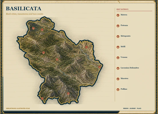
Illustrated map of Basilicata with eight numbered Merlintravel gateways
Merlintravel illustrated atlas · official ISTAT profile archived separately
The complete circuit

From Matera to Maratea across an inland mountain world.

The atlas links Matera and Metaponto to Potenza, Vulture, the Basento valley, Pollino and Maratea, showing the distance between Ionian and Tyrrhenian worlds.

Map markers identify the main places covered by the guides.

Four ways through

Journeys, not checklists.

The routes pair internationally known Matera with archaeological coasts, castle landscapes and mountain interiors.

01

Matera and the Murgia

Rock-cut neighbourhoods, plateau churches, water systems and deep ravines form one cultural landscape.

02

Metaponto and the Ionian

Greek temples, archaeology, wetlands and an agricultural coastal plain open the ancient east.

03

Vulture and Norman-Swabian Basilicata

Melfi, Venosa, volcanic lakes, abbeys and wine country shape the north.

04

Dolomiti Lucane, Pollino and Maratea

Mountain villages and a short dramatic Tyrrhenian shore reveal contrasting southern landscapes.

Eight territorial doors

Eight open chapters. The regional atlas is complete.

Every gateway now leads to a complete ten-chapter guide, with one distinct image for every chapter.

01

Matera and the Murgia

The Sassi, water systems, museums and plateau churches form one inhabited limestone landscape.

Open Matera and the Murgia
02

Potenza and the Lucanian Apennines

A mountain capital, Roman routes and the upper Agri valley reveal Basilicata’s central spine.

Open Potenza and the Apennines
04

Melfi, Monticchio and the Vulture

Castle, cathedral, volcanic lakes, abbey and wine towns connect medieval power to a living landscape.

Open Melfi and the Vulture
05

Venosa and the Upper Bradano

Roman Venusia, Jewish and Christian sites, castles and cultivated plateaux open the region’s north-east.

Open Venosa and the Upper Bradano
06

Lucanian Dolomites and Gallipoli Cognato

Rock villages, forest paths, ancient walls and living tree rituals define the Basento interior.

Open the Lucanian Dolomites
Living and monumental heritage

What the region keeps.

Monuments matter, but so do languages, crafts, routes, rituals and working landscapes.

01

Sassi and rupestrian churches

Matera’s heritage joins architecture to water, agriculture, social policy and human adaptation.

02

Greek and Lucanian archaeology

Metaponto, Policoro and inland museums reveal interaction rather than isolated colonial monuments.

03

Arbëreshë culture

Albanian-language communities preserve religious, linguistic and ritual traditions in the Pollino area.

04

Peasant and craft memory

Museums, festivals, bread, ceramics and weaving document lives often excluded from monumental histories.

Land and water

Nature is part of the archive.

Land, water and ecological systems are read together with the communities that have learned to inhabit them.

01

Pollino

Bosnian pines, high grasslands and river valleys cross the boundary with Calabria.

02

Vulture

An extinct volcano, crater lakes, forests and cultivated slopes distinguish northern Basilicata.

03

Murgia Materana

Limestone ravines, caves and plateau habitats are inseparable from human settlement.

04

Ionian and Tyrrhenian shores

A broad sandy east and a short rocky west create two very different maritime landscapes.

A documented journey, still open.

The Sassi are described as a long-lived urban and rural system marked by displacement, policy and restoration, not as caves discovered for tourism.

The journey continues.

Return to the Italy regional atlas