Apulia
Daunian and Messapian worlds, Roman roads, Romanesque ports, Frederick II, olive plains and two seas.
Apulia is a long Mediterranean threshold, not a single whitewashed coast.
Known locally and nationally as Puglia, the region stretches from Gargano and the Tavoliere through Bari and Valle d’Itria to Salento. Archaeology, eastern-facing ports, pilgrimage, Norman and Swabian monuments, dry-stone agriculture and contemporary towns create several souths within one region.
History in layers.
Daunians, Peucetians and Messapians preceded Roman Apulia. Byzantine, Lombard, Norman, Swabian, Angevin, Aragonese and Ottoman-facing histories then accumulated along a long coast.
Daunians, Peucetians and Messapians
Distinct pre-Roman cultures left settlements, ceramics, tombs and sculpted stone across the region.
Roman Apulia
The Via Appia, ports, colonies and farms connected the Adriatic and Ionian coasts to Rome.
Byzantine and Lombard frontiers
Long competition between powers shaped towns, rock churches and eastern cultural connections.
Normans and Frederick II
Cathedrals, castles and Castel del Monte turned Apulia into a key landscape of medieval monarchy.
Aragonese and Ottoman-facing coasts
Fortifications and port cities record conflict and exchange across the Adriatic and Ionian seas.
Land reform, migration and renewal
Large estates, peasant movements, modern cities and tourism transformed twentieth-century Puglia.

A long region between two seas.
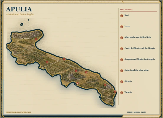
The atlas travels the full length from the Tremiti and Gargano to Bari, Castel del Monte, Taranto, Valle d’Itria, Lecce and Otranto.
Map markers identify editorial gateways, not a ranking.
Journeys, not checklists.
The four routes follow ancient cultural areas and maritime orientations instead of compressing Apulia into Salento alone.
Gargano and the north
Forests, pilgrimage, sea caves, Daunian sites and Tremiti islands define a varied northern peninsula.
Bari, Trani and Frederick’s landscape
Romanesque ports, castles and the Murgia connect commerce, pilgrimage and royal power.
Valle d’Itria and the Ionian
Trulli, masserie, olive landscapes and Taranto’s deep Greek history open the centre.
Lecce and Salento
Baroque stone, Messapian towns, coastal towers and Otranto’s eastern horizon form the southern circuit.
Places that open the story.
Each gateway is a future chapter: a city, landscape or cultural system large enough to deserve its own documented guide.
Bari
An Adriatic capital of old-city lanes, St Nicholas pilgrimage, port exchange and modern waterfront life.
Lecce
Messapian and Roman foundations beneath an exuberant local Baroque carved in warm limestone.
Alberobello and Valle d’Itria
Dry-stone trulli within a wider cultivated landscape of towns, masserie and fields.
Castel del Monte and the Murgia
Frederick II’s enigmatic castle within a limestone plateau of pastoral and agricultural routes.
Gargano and Monte Sant’Angelo
Ancient forest, dramatic coast and a major sanctuary on a long pilgrimage network.
Ostuni and the olive plain
A white hill town above monumental olive groves, farm complexes and the Adriatic shore.
Otranto
A fortified eastern port with cathedral mosaics, border memory and the open Adriatic horizon.
Taranto
A major Greek foundation, maritime city, archaeological collections and naval-industrial landscape.
What the region keeps.
Monuments matter, but so do languages, crafts, routes, rituals and working landscapes.
Romanesque ports
Bari, Trani, Bitonto and other cities developed powerful medieval stone architecture linked to sea routes.
Trulli and dry stone
UNESCO recognition concerns an architectural tradition embedded in land division and agricultural work.
Pilgrimage paths
Monte Sant’Angelo, Bari and the Via Francigena del Sud connect local sanctuaries to wider Christian routes.
Olive and wheat cultures
Ancient groves, mills, bread, pasta and masserie express both continuity and current environmental strain.
Nature is part of the archive.
Land, water and ecological systems are read together with the communities that have learned to inhabit them.
Gargano
Foresta Umbra, karst, cliffs and coastal wetlands form an exceptional northern peninsula.
Alta Murgia
Open limestone plateau, steppe habitats and pastoral routes surround farms and castles.
Torre Guaceto and coastal reserves
Dunes, wetlands, seagrass and traditional agriculture meet along protected shores.
Two seas
Adriatic and Ionian coasts differ in geology, settlement and maritime orientation across the long region.
A documented journey, still open.
The English page uses Apulia while acknowledging Puglia as the region’s Italian name. Trulli, masserie and olive groves are explained as building and production systems, not decorative symbols.
The journey continues.
Return to the Italy regional atlas